
|
From ‘Tribulation’ to ‘Perseverance’ on Mars
- Click the image above for a larger view
- Full-Res JPEG (1774 x 1417) (316.3 kB)
- Full-Res TIFF (1774 x 1417) (6.5 MB)
Caption:
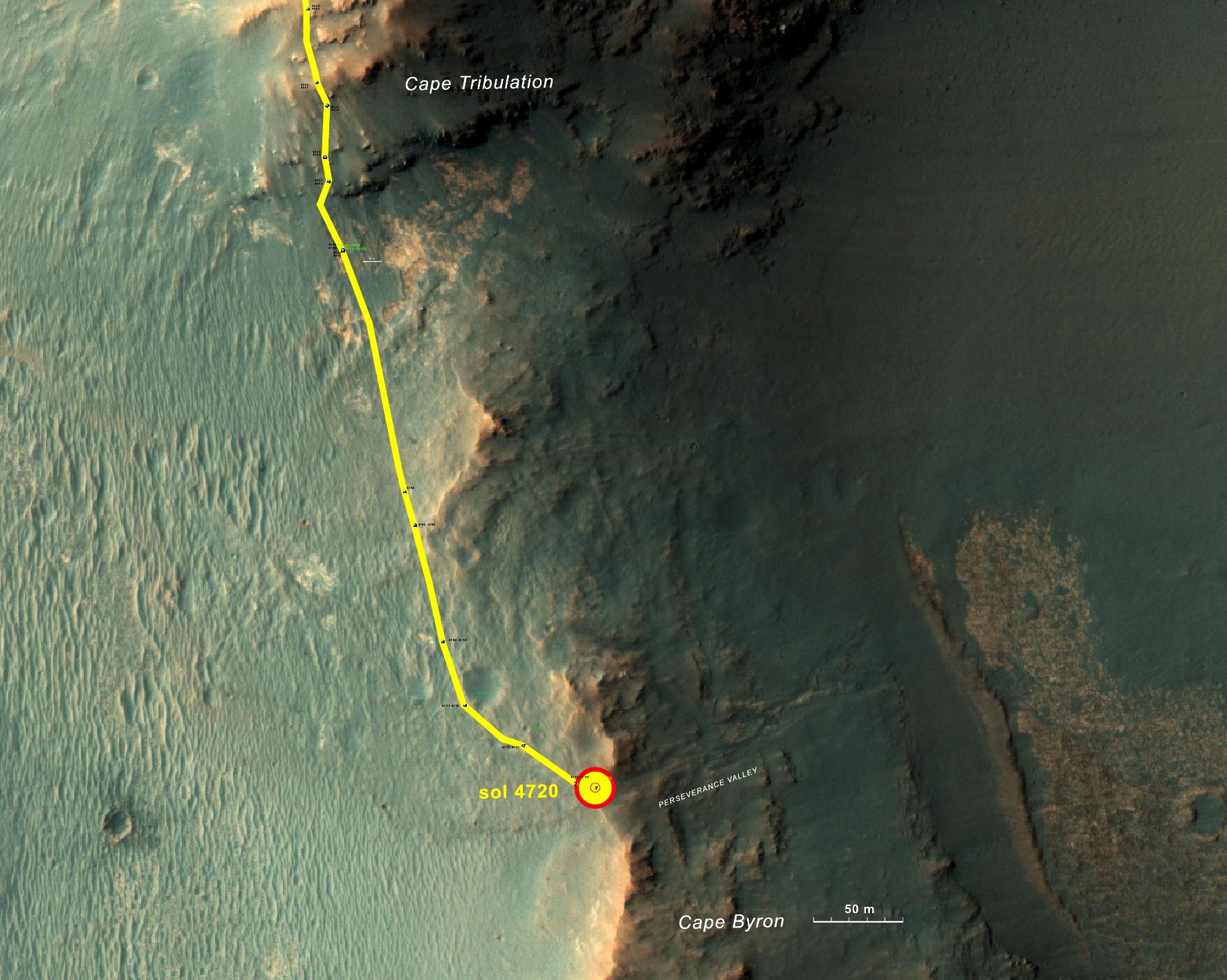
This graphic shows the route that NASA's Mars Exploration Rover Opportunity drove in its final approach to 'Perseverance Valley' on the western rim of Endeavour Crater.
The map covers an area about four-tenths of a mile (two-thirds of a kilometer) wide, with the interior of the crater on the right. Opportunity entered this mapped area from the north along the gold traverse line on March 21, 2017, approaching the southern tip of the "Cape Tribulation" segment of Endeavour's rim. It reached the top of "Perseverance Valley" with a drive on Sol 4720 (the 4,720th Martian day) of the mission, on May 4, 2017.
Images showing more of the Endeavour Crater rim are at PIA21490 and PIA17758 .
The base image for this map is from the High Resolution Imaging Science Experiment (HiRISE) camera on NASA's Mars Reconnaissance Orbiter. The annotated map was produced at the New Mexico Museum of Natural History and Science, Albuquerque.
Cataloging Keywords:
| Name | Value | Additional Values |
|---|---|---|
| Target | Mars | |
| System | ||
| Target Type | Planet | |
| Mission | Mars Exploration Rover (MER) | Mars 2020, Mars Reconnaissance Orbiter (MRO) |
| Instrument Host | Opportunity (MER-B) | Mars Reconnaissance Orbiter, Perseverance |
| Host Type | Rover | Orbiter |
| Instrument | High Resolution Imaging Science Experiment (HiRISE) | |
| Detector | ||
| Extra Keywords | Color, Crater, Map | |
| Acquisition Date | ||
| Release Date | 2017-05-15 | |
| Date in Caption | 2017-03-21 | 2017-05-04 |
| Image Credit | NASA/JPL-Caltech/Univ. of Arizona/NMMNH | |
| Source | photojournal.jpl.nasa.gov/catalog/PIA21496 | |
| Identifier | PIA21496 | |