|
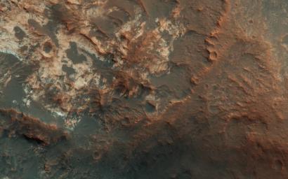
The Entrance to Mawrth Vallis
- Click the image above for a larger view
- Full-Res JPEG (2880 x 1800) (597.1 kB)
- Full-Res TIFF (2880 x 1800) (15.6 MB)
Caption:

Map Projected Browse Image
Click on the image for larger version
In Andy Weir's "The Martian," stranded astronaut Mark Watney drives from the Ares 3 landing site in Acidalia Planitia towards the Ares 4 landing site in Schiaparelli Crater via Mawrth Vallis. This image covers the entrance to Mawrth Vallis. (Have a look at the scene in 3D .)
As you can tell, driving over this terrain will be much more difficult than it was depicted in the novel or the movie.
The map is projected here at a scale of 50 centimeters (19.7 inches) per pixel. [The original image scale is 58.5 centimeters (19.1 inches) per pixel (with 2 x 2 binning); objects on the order of 176 centimeters (69.2 inches) across are resolved.] North is up.
This is a stereo pair with ESP_048595_2060 .
Background Info:
The University of Arizona, Tucson, operates HiRISE, which was built by Ball Aerospace & Technologies Corp., Boulder, Colo. NASA's Jet Propulsion Laboratory, a division of Caltech in Pasadena, California, manages the Mars Reconnaissance Orbiter Project for NASA's Science Mission Directorate, Washington.
Cataloging Keywords:
| Name | Value | Additional Values |
|---|---|---|
| Target | Mars | |
| System | ||
| Target Type | Planet | |
| Mission | Mars Reconnaissance Orbiter (MRO) | |
| Instrument Host | Mars Reconnaissance Orbiter | |
| Host Type | Orbiter | |
| Instrument | High Resolution Imaging Science Experiment (HiRISE) | |
| Detector | ||
| Extra Keywords | Color, Crater, Map | |
| Acquisition Date | ||
| Release Date | 2017-03-07 | |
| Date in Caption | ||
| Image Credit | NASA/JPL-Caltech/Univ. of Arizona | |
| Source | photojournal.jpl.nasa.gov/catalog/PIA21555 | |
| Identifier | PIA21555 | |
