|
A Crater on a Crater Wall
- Click the image above for a larger view
- Full-Res JPEG (2880 x 1800) (832.9 kB)
- Full-Res TIFF (2880 x 1800) (15.6 MB)
Caption:

Map Projected Browse Image
Click on the image for larger version
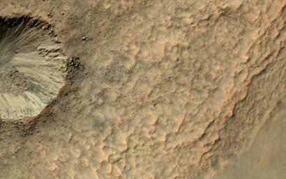
It's not that common to see craters on steep hills, partly because rocks falling downhill can quickly erase such craters. Here, however, NASA's Mars Reconnaissance Orbiter (MRO) observes a small impact has occurred on the sloping wall of a larger crater and is well-preserved.
Dark, blocky ejecta from the smaller crater has flowed downhill (to the west) toward the floor of the larger crater. Understanding the emplacement of such ejecta on steep hills is an area of ongoing research.
The map is projected here at a scale of 25 centimeters (9.8 inches) per pixel. [The original image scale is 24.8 centimeters (9.8 inches) per pixel (with 1 x 1 binning); objects on the order of 49.6 centimeters (19.5 inches) across are resolved.] North is up.
Background Info:
The University of Arizona, Tucson, operates HiRISE, which was built by Ball Aerospace & Technologies Corp., Boulder, Colo. NASA's Jet Propulsion Laboratory, a division of Caltech in Pasadena, California, manages the Mars Reconnaissance Orbiter Project for NASA's Science Mission Directorate, Washington.
Cataloging Keywords:
| Name | Value | Additional Values |
|---|---|---|
| Target | Mars | |
| System | ||
| Target Type | Planet | |
| Mission | Mars Reconnaissance Orbiter (MRO) | |
| Instrument Host | Mars Reconnaissance Orbiter | |
| Host Type | Orbiter | |
| Instrument | High Resolution Imaging Science Experiment (HiRISE) | |
| Detector | ||
| Extra Keywords | Color, Crater, Impact, Map | |
| Acquisition Date | ||
| Release Date | 2017-06-13 | |
| Date in Caption | ||
| Image Credit | NASA/JPL-Caltech/Univ. of Arizona | |
| Source | photojournal.jpl.nasa.gov/catalog/PIA21758 | |
| Identifier | PIA21758 | |
