|
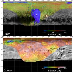
Global Mosaics of Pluto and Charon
- Click the image above for a larger view
- Full-Res JPEG (2130 x 2130) (627.4 kB)
- Full-Res TIFF (2130 x 2130) (8.2 MB)
Caption:
Global mosaics of Pluto and Charon projected at 300 meters (985 feet) per pixel that have been assembled from most of the highest resolution images obtained by the Long-Range Reconnaissance Imager (LORRI) and the Multispectral Visible Imaging Camera (MVIC) onboard New Horizons. Transparent, colorized stereo topography data generated for the encounter hemispheres of Pluto and Charon have been overlain on the mosaics. Terrain south of about 30°S on Pluto and Charon was in darkness leading up to and during the flyby, so is shown in black. "S" and "T" respectively indicate Sputnik Planitia and Tartarus Dorsa on Pluto, and "C" indicates Caleuche Chasma on Charon. All feature names on Pluto and Charon are informal.
Background Info:
The Johns Hopkins University Applied Physics Laboratory in Laurel, Maryland, designed, built, and operates the New Horizons spacecraft, and manages the mission for NASA's Science Mission Directorate. The Southwest Research Institute, based in San Antonio, leads the science team, payload operations and encounter science planning. New Horizons is part of the New Frontiers Program managed by NASA's Marshall Space Flight Center in Huntsville, Alabama.
Cataloging Keywords:
| Name | Value | Additional Values |
|---|---|---|
| Target | Pluto | Charon |
| System | Pluto | Kuiper Belt |
| Target Type | Satellite | Dwarf Planet, KBO |
| Mission | New Horizons | |
| Instrument Host | New Horizons | |
| Host Type | Flyby Spacecraft | |
| Instrument | Long Range Reconnaissance Imager (LORRI) | Multispectral Visible Imaging Camera (MVIC) |
| Detector | ||
| Extra Keywords | Color, Visual | |
| Acquisition Date | ||
| Release Date | 2017-07-14 | |
| Date in Caption | ||
| Image Credit | NASA/Johns Hopkins University Applied Physics Laboratory/Southwest Research Institute | |
| Source | photojournal.jpl.nasa.gov/catalog/PIA21862 | |
| Identifier | PIA21862 | |
