|
Exploring the Sandy Province of Herschel Crater
- Click the image above for a larger view
- Full-Res JPEG (2880 x 1800) (861.5 kB)
- Full-Res TIFF (2880 x 1800) (15.1 MB)
Caption:

Map Projected Browse Image
Click on the image for larger version
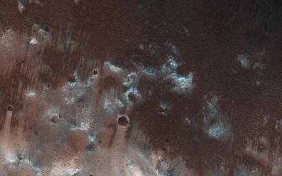
This view from NASA's Mars Reconnaissance Orbiter shows the downwind stretches of a sand sheet in central part of the much larger Herschel Crater. This sandy province began kilometers upwind in a string of barchan sand dunes. As the north-to-south blowing wind weakened downwind, it could no longer fashion the sand into dunes but rather into amorphously-shaped sand sheets .
While perhaps not awe-inspiringly beautiful, sand sheets can tell us about Mars' current and past environmental conditions as a piece of the puzzle for understanding habitability.
Having dunes upwind of sheets is the opposite situation Earth has, where upwind sand sheets evolve downwind into sand dunes. This mystery is receiving ongoing research to to understand these sandy differences between Earth and Mars.
The map is projected here at a scale of 25 centimeters (9.8 inches) per pixel. [The original image scale is 27.9 centimeters (11 inches) per pixel (with 1 x 1 binning); objects on the order of 84 centimeters (33.1 inches) across are resolved.] North is up.
Background Info:
The University of Arizona, Tucson, operates HiRISE, which was built by Ball Aerospace & Technologies Corp., Boulder, Colo. NASA's Jet Propulsion Laboratory, a division of Caltech in Pasadena, California, manages the Mars Reconnaissance Orbiter Project for NASA's Science Mission Directorate, Washington.
Cataloging Keywords:
| Name | Value | Additional Values |
|---|---|---|
| Target | Mars | |
| System | ||
| Target Type | Planet | |
| Mission | Mars Reconnaissance Orbiter (MRO) | |
| Instrument Host | Mars Reconnaissance Orbiter | |
| Host Type | Orbiter | |
| Instrument | High Resolution Imaging Science Experiment (HiRISE) | |
| Detector | ||
| Extra Keywords | Color, Crater, Dune, Map | |
| Acquisition Date | ||
| Release Date | 2017-09-04 | |
| Date in Caption | ||
| Image Credit | NASA/JPL-Caltech/Univ. of Arizona | |
| Source | photojournal.jpl.nasa.gov/catalog/PIA21933 | |
| Identifier | PIA21933 | |
