|
Layered Ice Near the South Pole of Mars
- Click the image above for a larger view
- Full-Res JPEG (2880 x 1800) (987.7 kB)
- Full-Res TIFF (2880 x 1800) (5.2 MB)
Caption:

Map Projected Browse Image
Click on the image for larger version
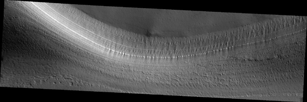
The two largest ice sheets in the inner solar system are here on Earth, Antarctica and Greenland. The third largest is at the South Pole of Mars and a small part of it is shown in this image from NASA's Mars Reconnaissance Orbiter (MRO).
Much like the terrestrial examples, this ice sheet is layered and scientists refer to it as the South Polar layered deposits. The ice layers contain information about past climates on Mars and deciphering this record has been a major goal of Mars science for decades. This slope, near the ice sheet's edge, shows the internal layers that have this climate record.
With stereo images, we can tell the heights of these layers so we can measure their thickness and try to unravel the climatic information they contain. (Be sure to view the digital terrain model for this observation.)
The map is projected here at a scale of 25 centimeters (9.8 inches) per pixel. [The original image scale is 25.0 centimeters (9.8 inches) per pixel (with 1 x 1 binning); objects on the order of 75 centimeters (29.5 inches) across are resolved.] North is up.
This is a stereo pair with ESP_024025_1005 .
Background Info:
The University of Arizona, Tucson, operates HiRISE, which was built by Ball Aerospace & Technologies Corp., Boulder, Colorado. NASA's Jet Propulsion Laboratory, a division of Caltech in Pasadena, California, manages the Mars Reconnaissance Orbiter Project for NASA's Science Mission Directorate, Washington.
Cataloging Keywords:
| Name | Value | Additional Values |
|---|---|---|
| Target | Mars | |
| System | ||
| Target Type | Planet | |
| Mission | Mars Reconnaissance Orbiter (MRO) | |
| Instrument Host | Mars Reconnaissance Orbiter | |
| Host Type | Orbiter | |
| Instrument | High Resolution Imaging Science Experiment (HiRISE) | |
| Detector | ||
| Extra Keywords | Grayscale, Map | |
| Acquisition Date | ||
| Release Date | 2017-12-12 | |
| Date in Caption | ||
| Image Credit | NASA/JPL-Caltech/Univ. of Arizona | |
| Source | photojournal.jpl.nasa.gov/catalog/PIA22125 | |
| Identifier | PIA22125 | |
