|
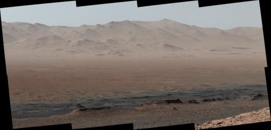
Telephoto Vista from Ridge in Mars’ Gale Crater
- Click the image above for a larger view
- Full-Res JPEG (4697 x 2263) (1.3 MB)
- Full-Res TIFF (4697 x 2263) (23.4 MB)
Caption:
|
Click on an individual image for full resolution figures image
A vantage point on "Vera Rubin Ridge" provided NASA's Curiosity Mars rover this detailed look back over the area where it began its mission inside Gale Crater, plus more-distant features of the crater.
This view toward the north-northeast combines eight images taken by the right-eye, telephoto-lens camera of Curiosity's Mast Camera (Mastcam). It shows more detail of a fraction of the area pictured in a more sweeping panorama ( PIA22210 ) acquired from the same rover location using Mastcam's left-eye, wider-angle-lens camera. The scene has been white-balanced so the colors of the rock materials resemble how they would appear under daytime lighting conditions on Earth.
The component images were taken on Oct. 25, 2017, during the 1,856th Martian day, or sol, of the rover's work on Mars. At that point, Curiosity had gained 1,073 feet (327 meters) in elevation and driven 10.95 miles (17.63 kilometers) from its landing site.
Mount Sharp stands about 3 miles (5 kilometers) high in the middle of Gale Crater, which spans 96 miles (154 kilometers) in diameter. Vera Rubin Ridge is on the northwestern flank of lower Mount Sharp. The right foreground of this panorama shows a portion of Vera Rubin Ridge. In the distance is the northern wall of Gale Crater, with the rim crest forming the horizon roughly 25 miles (40 kilometers) from the rover's location.
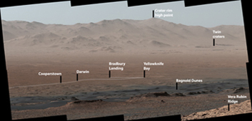
An annotated version, Figure 1, indicates where the rover landed (at "Bradbury Landing") in 2012 and the initial portion of its drive, including investigation sites "Yellowknife Bay," "Darwin" and "Cooperstown." The rover's exact landing site is hidden behind a slight rise. The heat shield, back shell, and parachute used during the spacecraft's descent are within the pictured area but not recognizable due to the distance and to camouflaging by dust. At Yellowknife Bay in 2013, the mission found evidence of an ancient freshwater-lake environment that offered all of the basic chemical ingredients for microbial life.
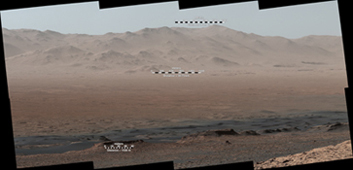
Figure 2 includes three scale bars: of 40 meters (131 feet) at a distance of about 1,530 meters (1,673 yards) near the base of Mount Sharp; of 1,500 meters (1,640 yards) at a distance of about 30.75 kilometers (19.1 miles) near the base of the crater wall; and of 2,000 meters (1.2 miles) at a distance of about 41.2 kilometers (25.6 miles) at the crest of the rim.
Background Info:
Malin Space Science Systems, San Diego, built and operates the Mastcam. NASA's Jet Propulsion Laboratory, a division of the Caltech in Pasadena, California, manages the Mars Science Laboratory Project for NASA's Science Mission Directorate, Washington. JPL designed and built the project's Curiosity rover.
More information about Curiosity is online at http://www.nasa.gov/msl and http://mars.jpl.nasa.gov/msl/ .
Cataloging Keywords:
| Name | Value | Additional Values |
|---|---|---|
| Target | Mars | |
| System | ||
| Target Type | Planet | |
| Mission | Mars Science Laboratory (MSL) | |
| Instrument Host | Curiosity Rover | |
| Host Type | Rover | |
| Instrument | Mast Camera (MastCam) | |
| Detector | ||
| Extra Keywords | Color, Crater, Dust, Water | |
| Acquisition Date | ||
| Release Date | 2018-01-30 | |
| Date in Caption | 2017-10-25 | |
| Image Credit | NASA/JPL-Caltech/MSSS | |
| Source | photojournal.jpl.nasa.gov/catalog/PIA22209 | |
| Identifier | PIA22209 | |


