|
Dust and Frost
- Click the image above for a larger view
- Full-Res JPEG (2880 x 1800) (1.2 MB)
- Full-Res TIFF (2880 x 1800) (15.6 MB)
Caption:

Map Projected Browse Image
Click on image for larger version
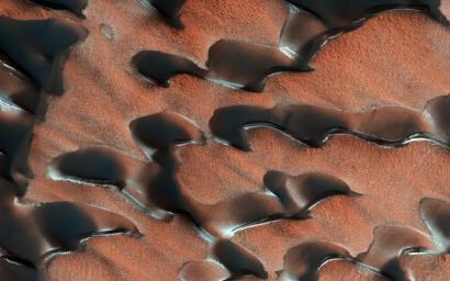
NASA's Mars Reconnaissance Orbiter (MRO) observed sand dunes in the north polar regions of Mars showing light coatings of pale orange dust blown partially across the dark basaltic sand. Around the edges of the dunes, patches of seasonal dry ice remain.
These patches will be gone soon as they sublimate (turn from ice to gas) in the summer sun. Some blocks of ice are visible at the foot of an alcove formed by a sand avalanche down the slipface of the dune.
The map is projected above at a scale of 25 centimeters (9.8 inches) per pixel. [The original image scale is 32.0 centimeters (12.6 inches) per pixel (with 1 x 1 binning); objects on the order of 96 centimeters (37.8 inches) across are resolved.] North is up.
Background Info:
The University of Arizona, Tucson, operates HiRISE, which was built by Ball Aerospace & Technologies Corp., Boulder, Colorado. NASA's Jet Propulsion Laboratory, a division of Caltech in Pasadena, California, manages the Mars Reconnaissance Orbiter Project for NASA's Science Mission Directorate, Washington.
Cataloging Keywords:
| Name | Value | Additional Values |
|---|---|---|
| Target | Mars | |
| System | ||
| Target Type | Planet | |
| Mission | Mars Reconnaissance Orbiter (MRO) | |
| Instrument Host | Mars Reconnaissance Orbiter | |
| Host Type | Orbiter | |
| Instrument | High Resolution Imaging Science Experiment (HiRISE) | |
| Detector | ||
| Extra Keywords | Color, Dune, Dust, Map | |
| Acquisition Date | ||
| Release Date | 2018-06-11 | |
| Date in Caption | ||
| Image Credit | NASA/JPL-Caltech/Univ. of Arizona | |
| Source | photojournal.jpl.nasa.gov/catalog/PIA22511 | |
| Identifier | PIA22511 | |
