|
Looking at Martian Salts and Clays
- Click the image above for a larger view
- Full-Res JPEG (2880 x 1800) (899.9 kB)
- Full-Res TIFF (2880 x 1800) (12.3 MB)
Caption:

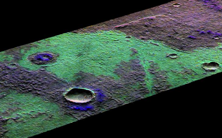
Map Projected Browse Image
Click on image for larger version
This 3D perspective view is a composite of both HiRISE and data from CRISM, another instrument onboard MRO. This view covers a small patch of ancient Martian real estate in Terra Sirenum.
CRISM collects spectral data that can be used as a chemical fingerprint for the upper most surface. This information suggests that this small patch of surface is covered with salts (chlorides) represented in green and water-rich clays that appear in blue.
CRISM colors can be added to high-resolution images to enhance our knowledge of these materials. They also match nicely with the surface features in our HiRISE image. For example, a fissure near the center of the image may be a a clue to the origin of the salts. The fissure may be a fracture where warm salt-laden water may have welled up, erupted and ponded on the surface. These waters then evaporated leaving the salt-rich deposits behind.
The map is projected here at a scale of 25 centimeters (9.8 inches) per pixel. [The original image scale is 25.4 centimeters (10 inches) per pixel (with 1 x 1 binning); objects on the order of 76 centimeters (30.0 inches) across are resolved.] North is up.
This is a stereo pair with PSP_006668_1470 .
Background Info:
The University of Arizona, Tucson, operates HiRISE, which was built by Ball Aerospace & Technologies Corp., Boulder, Colorado. NASA's Jet Propulsion Laboratory, a division of Caltech in Pasadena, California, manages the Mars Reconnaissance Orbiter Project for NASA's Science Mission Directorate, Washington.
Cataloging Keywords:
| Name | Value | Additional Values |
|---|---|---|
| Target | Mars | |
| System | ||
| Target Type | Planet | |
| Mission | Mars Reconnaissance Orbiter (MRO) | |
| Instrument Host | Mars Reconnaissance Orbiter | |
| Host Type | Orbiter | |
| Instrument | High Resolution Imaging Science Experiment (HiRISE) | Compact Reconnaissance Imaging Spectrometer for Mars (CRISM) |
| Detector | ||
| Extra Keywords | Color, Map, Water | |
| Acquisition Date | ||
| Release Date | 2018-11-27 | |
| Date in Caption | ||
| Image Credit | NASA/JPL-Caltech/University of Arizona | |
| Source | photojournal.jpl.nasa.gov/catalog/PIA22867 | |
| Identifier | PIA22867 | |