
|
Impact Near the South Pole
- Click the image above for a larger view
- Full-Res JPEG (2880 x 1800) (795.0 kB)
- Full-Res TIFF (2880 x 1800) (14.7 MB)
Caption:

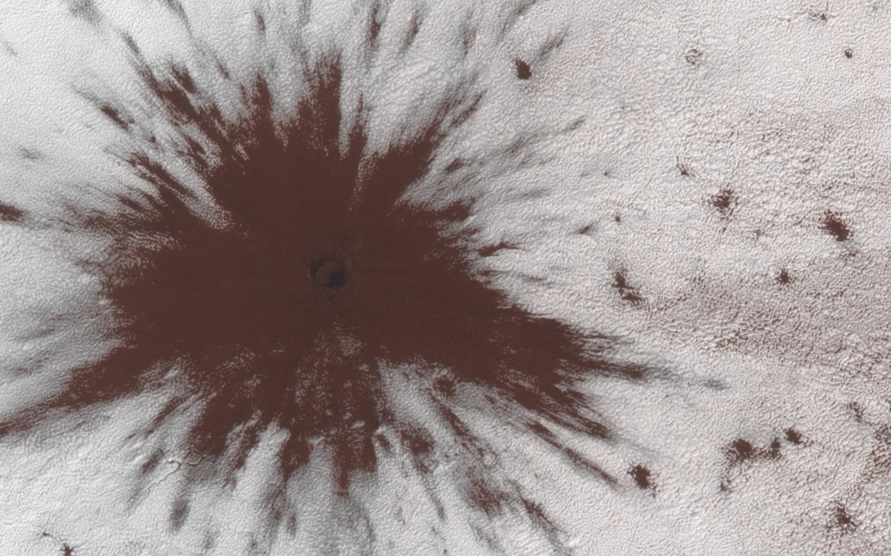
Map Projected Browse Image
Click on image for larger version
This image shows a new impact crater that formed between July and September 2018. It's notable because it occurred in the seasonal southern ice cap, and has apparently punched through it, creating a two-toned blast pattern.
The impact hit on the ice layer, and the tones of the blast pattern tell us the sequence. When an impactor hits the ground, there is a tremendous amount of force like an explosion. The larger, lighter-colored blast pattern could be the result of scouring by winds from the impact shockwave. The darker-colored inner blast pattern is because the impactor penetrated the thin ice layer, excavated the dark sand underneath, and threw it out in all directions on top of the layer.
The map is projected here at a scale of 25 centimeters (9.8 inches) per pixel. [The original image scale is 24.8 centimeters (9.8 inches) per pixel (with 1 x 1 binning); objects on the order of 74 centimeters (29.1 inches) across are resolved.] North is up.
Background Info:
The University of Arizona, Tucson, operates HiRISE, which was built by Ball Aerospace & Technologies Corp., Boulder, Colorado. NASA's Jet Propulsion Laboratory, a division of Caltech in Pasadena, California, manages the Mars Reconnaissance Orbiter Project for NASA's Science Mission Directorate, Washington.
Cataloging Keywords:
| Name | Value | Additional Values |
|---|---|---|
| Target | Mars | |
| System | ||
| Target Type | Planet | |
| Mission | Mars Reconnaissance Orbiter (MRO) | |
| Instrument Host | Mars Reconnaissance Orbiter | |
| Host Type | Orbiter | |
| Instrument | High Resolution Imaging Science Experiment (HiRISE) | |
| Detector | ||
| Extra Keywords | Color, Crater, Impact, Map | |
| Acquisition Date | ||
| Release Date | 2019-01-23 | |
| Date in Caption | ||
| Image Credit | NASA/JPL-Caltech/University of Arizona | |
| Source | photojournal.jpl.nasa.gov/catalog/PIA23019 | |
| Identifier | PIA23019 | |