
|
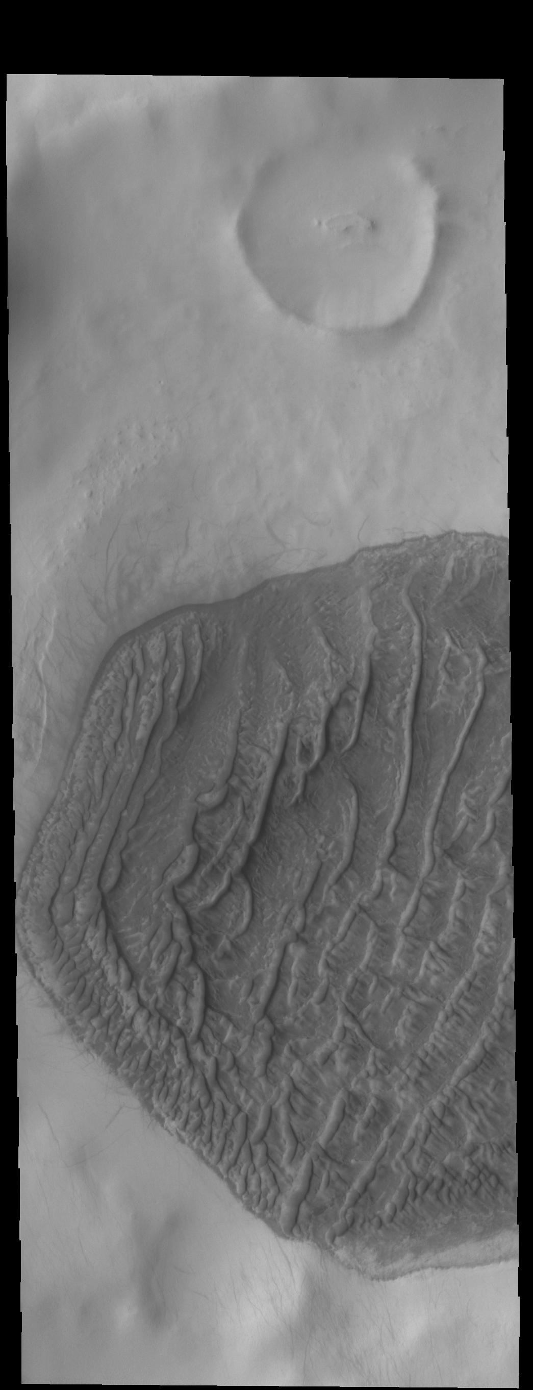
High Latitude Dunes
- Click the image above for a larger view
- Full-Res JPEG (1045 x 2722) (167.5 kB)
- Full-Res TIFF (1045 x 2722) (2.1 MB)
Caption:
Context image
Today's VIS image shows a dune field on a crater floor in Terra Cimmeria. Dunes at high latitudes - near the polar caps - are affected by seasonal frost and ice. The interactions with frost/ice reduces the amount of movement of sand grains within the dunes. This changes the morphology of near polar dunes when compared to dunes at lower latitudes where ice/frost do not occur as frequently. This crater's latitude is 68 degrees south of the equator.
Orbit Number: 75440 Latitude: -68.5479 Longitude: 163.063 Instrument: VIS Captured: 2018-12-16 23:56
Background Info:
Please see the THEMIS Data Citation Note for details on crediting THEMIS images.
NASA's Jet Propulsion Laboratory manages the 2001 Mars Odyssey mission for NASA's Science Mission Directorate, Washington, D.C. The Thermal Emission Imaging System (THEMIS) was developed by Arizona State University, Tempe, in collaboration with Raytheon Santa Barbara Remote Sensing. The THEMIS investigation is led by Dr. Philip Christensen at Arizona State University. Lockheed Martin Astronautics, Denver, is the prime contractor for the Odyssey project, and developed and built the orbiter. Mission operations are conducted jointly from Lockheed Martin and from JPL, a division of the California Institute of Technology in Pasadena.
Cataloging Keywords:
| Name | Value | Additional Values |
|---|---|---|
| Target | Mars | |
| System | ||
| Target Type | Planet | |
| Mission | 2001 Mars Odyssey | |
| Instrument Host | Mars Odyssey | |
| Host Type | Orbiter | |
| Instrument | Thermal Emission Imaging System (THEMIS) | |
| Detector | ||
| Extra Keywords | Crater, Dune, Grayscale, Thermal | |
| Acquisition Date | ||
| Release Date | 2019-02-14 | |
| Date in Caption | 2018-12-16 | |
| Image Credit | NASA/JPL-Caltech/ASU | |
| Source | photojournal.jpl.nasa.gov/catalog/PIA23035 | |
| Identifier | PIA23035 | |