|
Gullies in Galle
- Click the image above for a larger view
- Full-Res JPEG (2880 x 1800) (1.5 MB)
- Full-Res TIFF (2880 x 1800) (5.2 MB)
Caption:

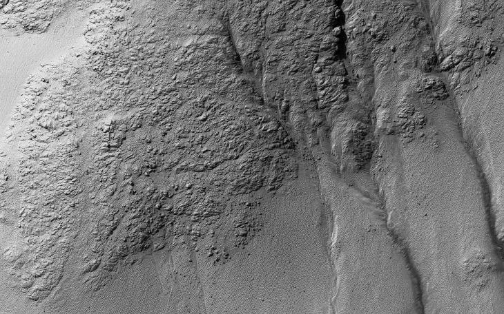
Map Projected Browse Image
Click on image for larger version
This image was taken of the hills that resulted from uplifted rocks due to an impact that formed the 230-kilometer diameter Galle Crater.
These hills form a segment of a circle known as a "peak ring" and this particular formation makes Galle Crater look like a "smiley face" from orbit.
Small gullies, visible in the center of this image , have formed on the flanks of these hills and they have eroded back into the bedrock. The crater itself is probably billions of years old, yet these gullies are likely only hundreds of thousands of years old and may even be active today.
The small channels in these gullies are easily erased by the wind over long time periods, so we know these gullies must have been active recently.
The map is projected here at a scale of 25 centimeters (9.8 inches) per pixel. [The original image scale is 25.7 centimeters (10.1 inches) per pixel (with 1 x 1 binning); objects on the order of 77 centimeters (30.3 inches) across are resolved.] North is up.
Background Info:
The University of Arizona, Tucson, operates HiRISE, which was built by Ball Aerospace & Technologies Corp., Boulder, Colorado. NASA's Jet Propulsion Laboratory, a division of Caltech in Pasadena, California, manages the Mars Reconnaissance Orbiter Project for NASA's Science Mission Directorate, Washington.
Cataloging Keywords:
| Name | Value | Additional Values |
|---|---|---|
| Target | Mars | |
| System | ||
| Target Type | Planet | |
| Mission | Mars Reconnaissance Orbiter (MRO) | |
| Instrument Host | Mars Reconnaissance Orbiter | |
| Host Type | Orbiter | |
| Instrument | High Resolution Imaging Science Experiment (HiRISE) | |
| Detector | ||
| Extra Keywords | Color, Crater, Impact, Map | |
| Acquisition Date | ||
| Release Date | 2019-03-04 | |
| Date in Caption | ||
| Image Credit | NASA/JPL-Caltech/University of Arizona | |
| Source | photojournal.jpl.nasa.gov/catalog/PIA23078 | |
| Identifier | PIA23078 | |