|
Mid-2019 Map of NASA’s Curiosity Rover Mission
- Click the image above for a larger view
- Full-Res JPEG (3300 x 2550) (1.7 MB)
- Full-Res TIFF (3300 x 2550) (13.3 MB)
Caption:
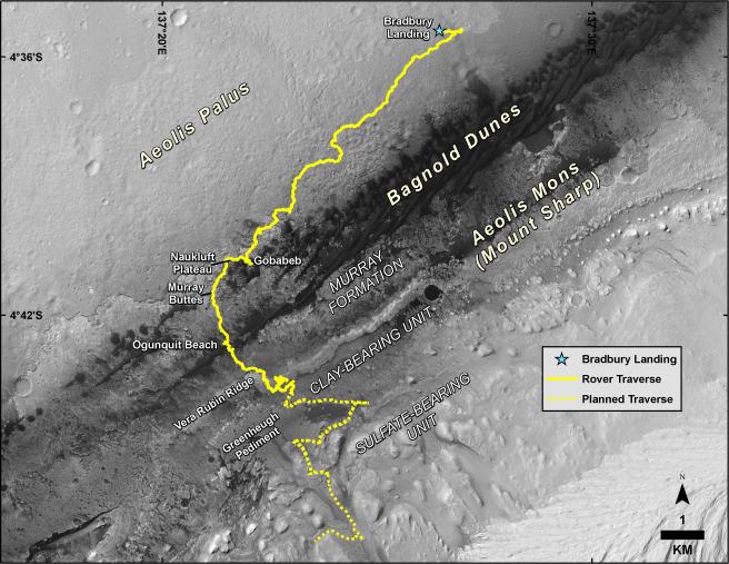
This map shows the route driven by NASA's Curiosity Mars rover, from the location where it landed in August 2012 to its location in August 2019, and its planned path to additional geological layers of lower "Mount Sharp." The blue star near top center marks "Bradbury Landing," the site where Curiosity arrived on Mars on Aug. 5, 2012, PDT (Aug. 6, EDT and Universal Time). Curiosity landed on Aeolis Palus, the plains surrounding Aeolis Mons (Mount Sharp) in Gale Crater.
The base image for the map is from the High Resolution Imaging Science Experiment (HiRISE) camera on the Mars Reconnaissance Orbiter. North is up. "Bagnold Dunes" form a band of dark, wind-blown material at the foot of Mount Sharp.
The scale bar at lower right represents one kilometer (0.62 mile). For a broader-context image of the area, see PIA16058 .
Background Info:
NASA's Jet Propulsion Laboratory, a division of Caltech in Pasadena, California, manages the Mars Science Laboratory Project and Mars Reconnaissance Orbiter Project for NASA's Science Mission Directorate, Washington. For more information about Curiosity, visit http://www.nasa.gov/msl and http://mars.jpl.nasa.gov/msl/ .
Cataloging Keywords:
| Name | Value | Additional Values |
|---|---|---|
| Target | Mars | |
| System | ||
| Target Type | Planet | |
| Mission | Mars Science Laboratory (MSL) | Mars Reconnaissance Orbiter (MRO) |
| Instrument Host | Curiosity Rover | Mars Reconnaissance Orbiter |
| Host Type | Rover | Orbiter |
| Instrument | High Resolution Imaging Science Experiment (HiRISE) | |
| Detector | ||
| Extra Keywords | Color, Crater, Dune, Map, Mountain | |
| Acquisition Date | ||
| Release Date | 2019-08-22 | |
| Date in Caption | 2012-08-05 | |
| Image Credit | NASA/JPL-Caltech/Univ. of Arizona | |
| Source | photojournal.jpl.nasa.gov/catalog/PIA23412 | |
| Identifier | PIA23412 | |