
|
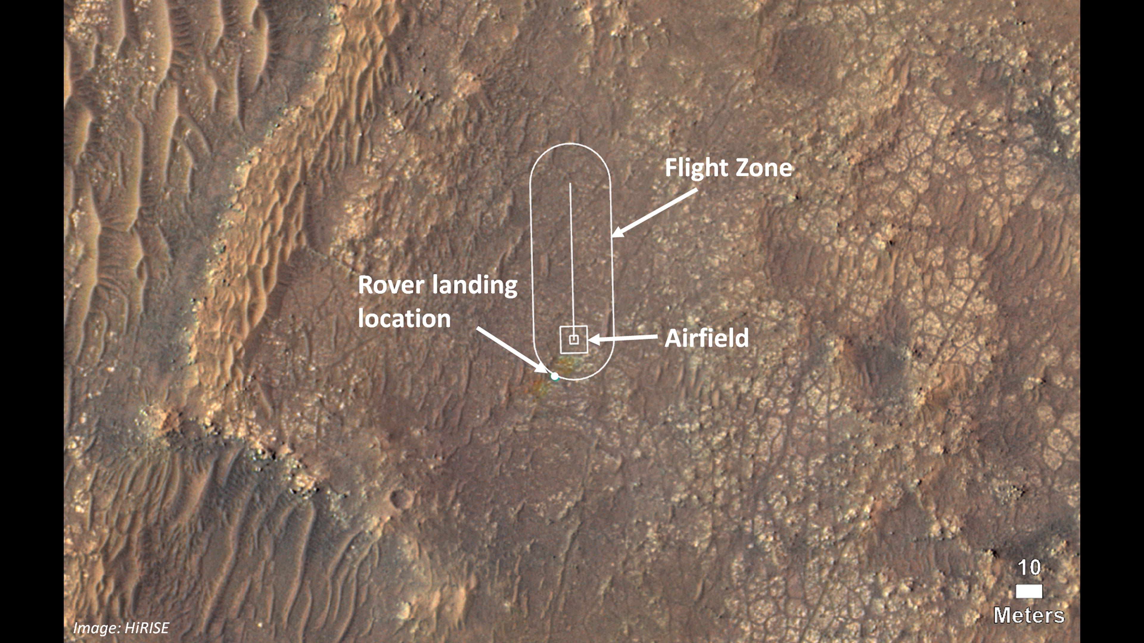
Map of Ingenuity Helicopter Flight Zone
- Click the image above for a larger view
- Full-Res JPEG (3840 x 2160) (802.3 kB)
- Full-Res TIFF (3840 x 2160) (23.2 MB)
Caption:
This image shows where NASA's Ingenuity Mars Helicopter team will attempt its test flights. Helicopter engineers added the locations for the rover landing site (also known as "Octavia E. Butler Landing"), the airfield (the area where the helicopter will take off and return), and the flight zone (the area within which it will fly) on an image taken by the High Resolution Imaging Experiment (HiRISE) camera aboard NASA's Mars Reconnaissance Orbiter.
Some small rainbow-like color distortions (which do not actually appear on the terrain of Mars) are seen in this image near the landing location because of the way pre- and post-landing color images were merged.
Background Info:
The Ingenuity Mars Helicopter technology demonstration activity is supported by NASA's Science Mission Directorate, the NASA Aeronautics Research Mission Directorate, and the NASA Space Technology Mission Directorate.
NASA's Jet Propulsion Laboratory built and manages operations of Perseverance and Ingenuity for the agency. Caltech in Pasadena, California, manages JPL for NASA.
Cataloging Keywords:
| Name | Value | Additional Values |
|---|---|---|
| Target | Mars | |
| System | ||
| Target Type | Planet | |
| Mission | Mars Reconnaissance Orbiter (MRO) | Mars 2020 |
| Instrument Host | Mars Reconnaissance Orbiter | Ingenuity, Perseverance |
| Host Type | Orbiter | Helicopter, Rover |
| Instrument | High Resolution Imaging Science Experiment (HiRISE) | |
| Detector | ||
| Extra Keywords | Color, Map | |
| Acquisition Date | ||
| Release Date | 2021-03-23 | |
| Date in Caption | ||
| Image Credit | NASA/JPL-Caltech/University of Arizona | |
| Source | photojournal.jpl.nasa.gov/catalog/PIA24494 | |
| Identifier | PIA24494 | |