|
Layers Blanket a Crater Floor
- Click the image above for a larger view
- Full-Res JPEG (2880 x 1800) (879.7 kB)
- Full-Res TIFF (2880 x 1800) (15.6 MB)
Caption:

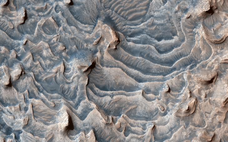
Map Projected Browse Image
Click on image for larger version
This image shows a layered rock formation within Jiji Crater that has eroded into buttes and stair-like layers.
This formation extends west and east . Similar layered rocks are within several craters in Arabia Terra and Meridiani Planum, including Sera and Banes craters. The similarities suggest that the same process was forming deposits over a large geographic area long ago. Our image also indicates that much of the formation has eroded away relative to what has remained.
Multiple HiRISE images within Jiji Crater allow scientists to evaluate how similar or different layers are over this area, which can help them understand geologic layers and their properties over greater distances.
The map is projected here at a scale of 25 centimeters (9.8 inches) per pixel. (The original image scale is 31.9 centimeters [12.6 inches] per pixel [with 1 x 1 binning]; objects on the order of 96 centimeters [37.8 inches] across are resolved.) North is up.
This is a stereo pair with ESP_065360_1900 .
Background Info:
The University of Arizona, in Tucson, operates HiRISE, which was built by Ball Aerospace & Technologies Corp., in Boulder, Colorado. NASA's Jet Propulsion Laboratory, a division of Caltech in Pasadena, California, manages the Mars Reconnaissance Orbiter Project for NASA's Science Mission Directorate, Washington.
Cataloging Keywords:
| Name | Value | Additional Values |
|---|---|---|
| Target | Mars | |
| System | ||
| Target Type | Planet | |
| Mission | Mars Reconnaissance Orbiter (MRO) | |
| Instrument Host | Mars Reconnaissance Orbiter | |
| Host Type | Orbiter | |
| Instrument | High Resolution Imaging Science Experiment (HiRISE) | |
| Detector | ||
| Extra Keywords | Color, Crater, Map | |
| Acquisition Date | ||
| Release Date | 2021-07-28 | |
| Date in Caption | ||
| Image Credit | NASA/JPL-Caltech/University of Arizona | |
| Source | photojournal.jpl.nasa.gov/catalog/PIA24697 | |
| Identifier | PIA24697 | |