
|
Angustus Labyrinthus - Inca City
- Click the image above for a larger view
- Full-Res JPEG (260 x 2750) (67.5 kB)
- Full-Res TIFF (260 x 2750) (685.5 kB)
Caption:
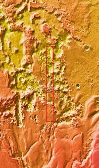
Context image
Today's VIS image shows part of Angustus Labyrinthus. Angustus Labyrinthus is a unique region near the south polar cap. In the center of this image squares formed by intersecting ridges are visible. The feature earned the informal name of the Inca City when it was discovered in Mariner 9 images in 1972.The linear ridges are believed to have formed by volcanic and tectonic forces, where magma filled fractures in the subsurface and then erosion revealed the magmatic material.
Orbit Number: 85024 Latitude: -81.1964 Longitude: 296.058 Instrument: VIS Captured: 2021-02-13 03:55
Background Info:
Please see the THEMIS Data Citation Note for details on crediting THEMIS images.
NASA's Jet Propulsion Laboratory manages the 2001 Mars Odyssey mission for NASA's Science Mission Directorate, Washington, D.C. The Thermal Emission Imaging System (THEMIS) was developed by Arizona State University, Tempe, in collaboration with Raytheon Santa Barbara Remote Sensing. The THEMIS investigation is led by Dr. Philip Christensen at Arizona State University. Lockheed Martin Astronautics, Denver, is the prime contractor for the Odyssey project, and developed and built the orbiter. Mission operations are conducted jointly from Lockheed Martin and from JPL, a division of the California Institute of Technology in Pasadena.
Cataloging Keywords:
| Name | Value | Additional Values |
|---|---|---|
| Target | Mars | |
| System | ||
| Target Type | Planet | |
| Mission | 2001 Mars Odyssey | Mariner |
| Instrument Host | Mars Odyssey | |
| Host Type | Orbiter | Flyby Spacecraft |
| Instrument | Thermal Emission Imaging System (THEMIS) | |
| Detector | ||
| Extra Keywords | Grayscale, Thermal, Volcano | |
| Acquisition Date | ||
| Release Date | 2021-07-23 | |
| Date in Caption | 2021-02-13 | |
| Image Credit | NASA/JPL-Caltech/ASU | |
| Source | photojournal.jpl.nasa.gov/catalog/PIA24740 | |
| Identifier | PIA24740 | |