Venus - Lineated Plains in Lakshmi Region
Caption:
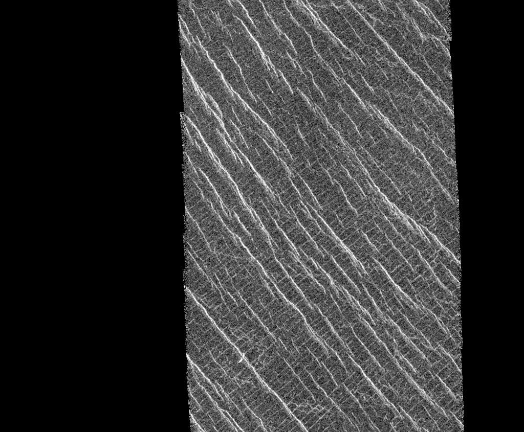
This mosaic shows an area of the Lakshmi region that is located 30 degrees north latitude and 333.3 degrees east longitude. (Longitude on Venus is measured from 0 degrees to 360 degrees east). The area shown measures about 37 kilometers (23 miles) wide and 80 kilometers (50 miles) long. Based on data from the Pioneer Venus Orbiter and the ground-based Arecibo Radar Observatory, it is known that this region is located on the low rise that separates Sedna Planitia and Guinevere Planitia, just to the west of Eistla Regio. Two sets of parallel lineations are seen intersecting almost at right angles. The fainter lineations are spaced at regular intervals of about one kilometer (0.6 mile) and extend beyond the boundary of the image. The width of the faint lineations is at the limit of resolution of the best Magellan images. The brighter, more dominant lineations are less regular and, in places, appear to begin and end where they intersect the fainter lineations. It is not clear whether the two sets of lineations are faults or fractures, but in other Magellan images, these bright lineations are associated with pit craters and volcanic features. This type of terrain has not been seen on Venus nor on other planets. North is at the top of the image.
Cataloging Keywords:
| Name |
Value |
Additional Values |
| Target |
Venus |
|
| System |
|
|
| Target Type |
Planet |
|
| Mission |
Magellan |
National Astronomy and Ionosphere Center (NAIC), Pioneer Venus |
| Instrument Host |
Magellan |
Arecibo Observatory, Pioneer Venus Orbiter |
| Host Type |
Orbiter |
Flyby Spacecraft, Ground-Based Observatory |
| Instrument |
Imaging Radar |
Arecibo Radar |
| Detector |
|
|
| Extra Keywords |
Crater, Grayscale, Radar, Volcano |
| Acquisition Date |
|
| Release Date |
1996-01-29 |
| Date in Caption |
|
|
| Image Credit |
NASA/JPL |
| Source |
photojournal.jpl.nasa.gov/catalog/PIA00085 |
| Identifier |
PIA00085 |
