Perspective View of Ishtar Terra
Caption:
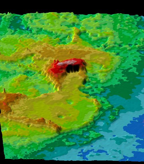
This perspective view of Ishtar Terra was derived from data obtained by the Pioneer Venus spacecraft's altimetry radar instrument. Ishtar viewed from the west (bottom of image) is centered at about 65 degrees north latitude and 0 degrees longitude. Ishtar (approximately equal in size to Australia) is a large plateau standing 3.3 km above the surrounding lowlands, bounded by relatively steep slopes. Rising above this plateau are three massifs: Akna Montes and Freyja Montes along the western and northwestern edge of Lakshmi Planum, and Maxwell Montes along its eastern edge. The eastern part of Ishtar, east of Maxwell, is a complex hilly terrain ~1 km lower than Lakshmi Planum that lacks the steep well-defined boundary slopes that characterize the plateau. Maxwell Montes, highest point on the planet is elevated more than 10 km (32,000 ft) above the surrounding lowlands. Color-coded altimetry shows elevations in .5 and 1 km intervals. Cool colors mark low elevations and warm colors mark high elevations
Cataloging Keywords:
| Name |
Value |
Additional Values |
| Target |
Venus |
|
| System |
|
|
| Target Type |
Planet |
|
| Mission |
Pioneer Venus |
|
| Instrument Host |
Pioneer Venus Orbiter |
|
| Host Type |
Orbiter |
Flyby Spacecraft |
| Instrument |
Imaging Radar |
|
| Detector |
|
|
| Extra Keywords |
Color, Mountain, Radar |
| Acquisition Date |
|
| Release Date |
1998-06-03 |
| Date in Caption |
|
|
| Image Credit |
NASA/JPL/USGS |
| Source |
photojournal.jpl.nasa.gov/catalog/PIA00093 |
| Identifier |
PIA00093 |
