skip to navigation

|
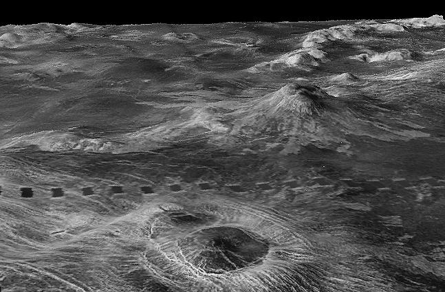
Three-dimensional perspective views of Venusian Terrains composed of reduced resolution left-looking synthetic-aperture radar images merged with altimetry data from the Magellan spacecraft.
- Click the image above for a larger view
- Full-Res JPEG (647 x 425) (68.5 kB)
- Full-Res TIFF (647 x 425) (268.7 kB)
Caption:
The view shows part of Galindo (V40) quadrangle looking north; 200 km wide Nagavonyi Corona is in the foreground. Coronae are roughly circular, volcanic features believed to form over hot upwellings of magma within the Venusian mantle. A 2-km shield volcano behind the corona partly buries the Phoebo Regio highlands (shown as radar-bright mounds).
Cataloging Keywords:
| Name | Value | Additional Values |
|---|---|---|
| Target | Venus | |
| System | ||
| Target Type | Planet | |
| Mission | Magellan | |
| Instrument Host | Magellan | |
| Host Type | Orbiter | |
| Instrument | Imaging Radar | |
| Detector | ||
| Extra Keywords | Grayscale, Radar, Volcano | |
| Acquisition Date | ||
| Release Date | 1998-06-03 | |
| Date in Caption | ||
| Image Credit | NASA/JPL/USGS | |
| Source | photojournal.jpl.nasa.gov/catalog/PIA00095 | |
| Identifier | PIA00095 | |