skip to navigation

|
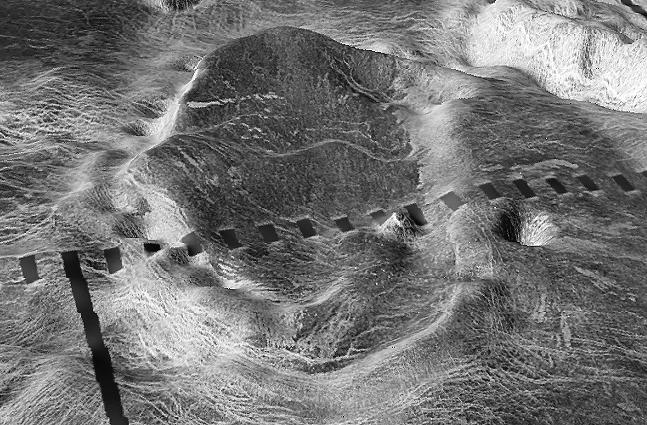
Close-up View of Atete Corona
- Click the image above for a larger view
- Full-Res JPEG (647 x 425) (86.9 kB)
- Full-Res TIFF (647 x 425) (324.3 kB)
Caption:
The view is a close-up of Atete Corona, a 600-km-long and 450-km-wide feature at latitude 16 degrees S., longitude 244 degrees; looking north. Coronae are roughly circular volcanic features believed to form over hot upwellings of magma within the Venusian mantle. The north end of the corona bounds Parga Chasma, a 0-3 km deep depression that spans 1,870 km connecting Themis Regio (latitude 35 degrees S., longitude 285 degrees) and Maat Mons (latitude 0 degree, longitude 195 degrees).
This is a three-dimensional perspective view of Venusian Terrains composed of reduced resolution left-looking synthetic-aperture radar images merged with altimetry data from the Magellan spacecraft.
Cataloging Keywords:
| Name | Value | Additional Values |
|---|---|---|
| Target | Venus | |
| System | ||
| Target Type | Planet | |
| Mission | Magellan | |
| Instrument Host | Magellan | |
| Host Type | Orbiter | |
| Instrument | Imaging Radar | |
| Detector | ||
| Extra Keywords | Grayscale, Mountain, Radar, Volcano | |
| Acquisition Date | ||
| Release Date | 1998-06-03 | |
| Date in Caption | ||
| Image Credit | NASA/JPL/USGS | |
| Source | photojournal.jpl.nasa.gov/catalog/PIA00097 | |
| Identifier | PIA00097 | |