
|
Miranda’s Geologic History (Variety of Terrain)
- Click the image above for a larger view
- Full-Res JPEG (774 x 787) (63.4 kB)
- Full-Res TIFF (774 x 787) (288.8 kB)
Caption:
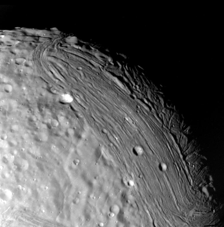
Miranda reveals a complex geologic history in this view, acquired by Voyager 2 on Jan. 24, 1986, around its close approach to the Uranian moon. At least three terrain types of different age and geologic style are evident at this resolution of about 700 meters (2,300 feet). Visible in this clear-filter, narrow-angle image are, from left: (1) an apparently ancient, cratered terrain consisting of rolling, subdued hills and degraded medium-sized craters (2) a grooved terrain with linear valleys and ridges developed at the expense of, or replacing, the first terrain type: and (3) a complex terrain seen along the terminator, in which intersecting curvilinear ridges and troughs are abruptly truncated by the linear, grooved terrain. Voyager scientists believe this third terrain type is intermediate in age between the first two.
Background Info:
The Voyager project is managed for NASA by the Jet Propulsion Laboratory.
Cataloging Keywords:
| Name | Value | Additional Values |
|---|---|---|
| Target | Miranda | |
| System | Uranus | |
| Target Type | Satellite | |
| Mission | Voyager | |
| Instrument Host | Cassini Orbiter | Voyager 2 |
| Host Type | Orbiter | Flyby Spacecraft |
| Instrument | Imaging Science Subsystem (ISS) | |
| Detector | Narrow Angle Camera | |
| Extra Keywords | Crater, Grayscale, Visual | |
| Acquisition Date | ||
| Release Date | 1996-01-29 | |
| Date in Caption | 1986-01-24 | |
| Image Credit | NASA/JPL | |
| Source | photojournal.jpl.nasa.gov/catalog/PIA00141 | |
| Identifier | PIA00141 | |