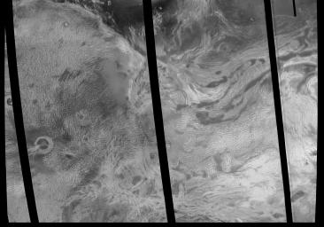
Venus - Ovda Regio
Caption:
This image covers much of Ovda Regio, which forms the western part of Aphrodite Terra. It covers an area about 2,250 kilometers (1,386 miles) wide by 1,300 kilometers (800 miles) north to south, and ranges in latitude from 8 degrees north to 12 degrees south and in longitude from 62 degrees east to 90 degrees east. Ovda Regio is a highland region that rises over 4 kilometers (2.5 miles) above the surrounding plain. Magellan images show a complex surface, with several generations of structures. A pervasive fabric of irregular broad domes and ridges and associated curvilinear valleys was flooded by lava, then fractured. The circular feature surrounded by dark lava flows in the western part of the image is a caldera, or large volcanic collapse pit. Late-stage extension created long graben, or fault-bounded valleys, is best seen near the center of the image. The northern boundary of Ovda Regio is a steep, curvilinear mountain belt made up of long, narrow, rounded ridges. These ridges are similar in appearance to folded mountain belts on Earth. Several impact craters, such as the circular features on the western margin of the image, are scattered across the area. The bright area in the southeast part of the image indicates the presence of a radar-reflective mineral such as pyrite. Most of the highland areas on Venus display a similar bright signal. Each pixel of this image covers an area on the surface 675 meters (2,215 feet) across, representing a 9- times reduction in resolution compared to full-scale resolution data.
Cataloging Keywords:
| Name |
Value |
Additional Values |
| Target |
Venus |
|
| System |
|
|
| Target Type |
Planet |
|
| Mission |
Magellan |
|
| Instrument Host |
Magellan |
|
| Host Type |
Orbiter |
|
| Instrument |
Imaging Radar |
|
| Detector |
|
|
| Extra Keywords |
Crater, Grayscale, Impact, Mountain, Radar, Volcano |
| Acquisition Date |
|
| Release Date |
1996-08-13 |
| Date in Caption |
|
|
| Image Credit |
NASA/JPL |
| Source |
photojournal.jpl.nasa.gov/catalog/PIA00146 |
| Identifier |
PIA00146 |

