skip to navigation
|
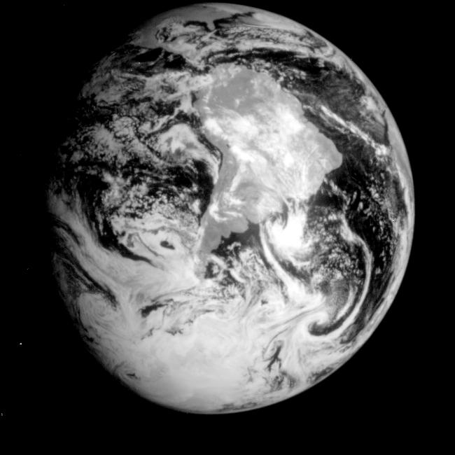
Global View of Earth in the Near-Infrared
- Click the image above for a larger view
- Full-Res JPEG (650 x 650) (44.2 kB)
- Full-Res TIFF (650 x 650) (223.3 kB)
Caption:
This near-infrared photograph of the Earth was taken by the Galileo spacecraft at 6:07 a.m. PST on Dec. 11, 1990, at a range of about 1.32 million miles. The camera used light with a wavelength of 1 micron, which easily penetrates atmospheric hazes and enhances the brightness of land surfaces. South America is prominent near the center; at the top, the East Coast of the United States, including Florida, is visible. The West Coast of Africa is visible on the horizon at right.
Cataloging Keywords:
| Name | Value | Additional Values |
|---|---|---|
| Target | Earth | |
| System | Earth | |
| Target Type | Earth | |
| Mission | Galileo | |
| Instrument Host | Galileo Orbiter | |
| Host Type | Orbiter | |
| Instrument | Solid-State Imaging (SSI) | |
| Detector | ||
| Extra Keywords | Atmosphere, Grayscale, Haze, Infrared | |
| Acquisition Date | ||
| Release Date | 1996-02-08 | |
| Date in Caption | 1990-12-11 | |
| Image Credit | NASA/JPL | |
| Source | photojournal.jpl.nasa.gov/catalog/PIA00226 | |
| Identifier | PIA00226 | |