Venus - Simple Cylindrical Map of Surface (Eastern Half)
Caption:
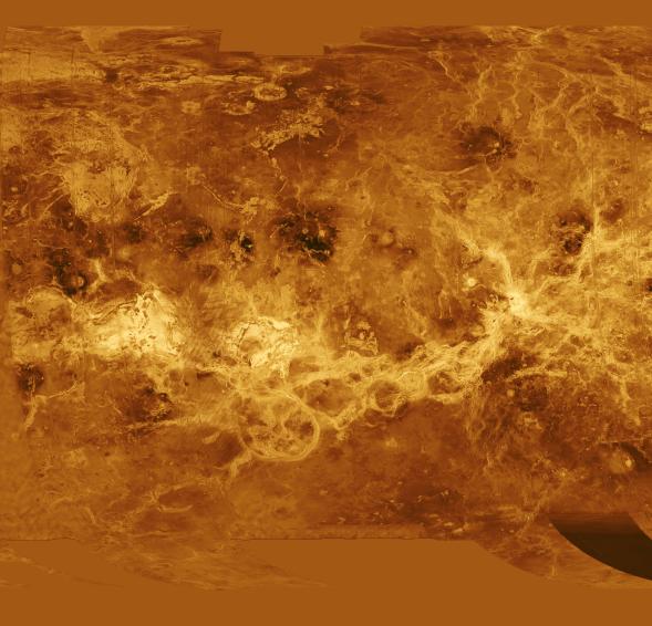
The eastern half of the planet is displayed in this simple cylindrical map of the surface of Venus. The left edge of the image is at 52.5 degrees east longitude, the right edge at 240 degrees east longitude. The top and bottom of the image are at 90 degrees north latitude and 90 degrees south latitude, respectively. Magellan synthetic aperture radar mosaics from the first cycle of Magellan mapping are mapped onto a rectangular latitude-longitude grid to create this image. Data gaps are filled with Pioneer Venus Orbiter altimetric data, or a constant mid-range value. Simulated color is used to enhance small-scale structure. The simulated hues are based on color images recorded by the Soviet Venera 13 and 14 spacecraft. The image was produced by the Solar System Visualization project and the Magellan science team at the JPL Multimission Image Processing Laboratory.
Cataloging Keywords:
| Name |
Value |
Additional Values |
| Target |
Venus |
|
| System |
|
|
| Target Type |
Planet |
|
| Mission |
Magellan |
Pioneer Venus |
| Instrument Host |
Magellan |
Pioneer Venus Orbiter |
| Host Type |
Orbiter |
Flyby Spacecraft |
| Instrument |
Imaging Radar |
|
| Detector |
|
|
| Extra Keywords |
Color, Map, Radar |
| Acquisition Date |
|
| Release Date |
1996-09-30 |
| Date in Caption |
|
|
| Image Credit |
NASA/JPL |
| Source |
photojournal.jpl.nasa.gov/catalog/PIA00256 |
| Identifier |
PIA00256 |