|
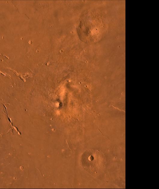
Elysium
- Click the image above for a larger view
- Full-Res JPEG (2100 x 2491) (403.0 kB)
- Full-Res TIFF (2100 x 2491) (7.2 MB)
Caption:
A color image of the Elysium Region of Mars; north toward top. The scene shows the Elysium Mons volcano (center), Hecates Tholus (to the north), Albor Tholus (to the south), and the depressions of Elysium Fossae. Mons is a Latin term for mountain; the term tholus designates a small mountain or dome.
This image is a composite of Viking medium-resolution images in black and white and low-resolution images in color. The image extends from latitude 16 degrees N. to 35 degrees N. and from longitude 206 degrees to 220 degrees; Mercator projection.
The Elysium region contain the second largest volcanic complex on Mars, surpassed in size by only the Tharsis complex. Elysium Mons, whose summit elevation is 16,000 m above the Martian datum, is at the crest of a regional topographic rise that emerges steeply and abruptly from the surrounding plains. The relief of Hecates is about 6,000 m and the relief of Albor is only about 4,000 m, because Hecates is on the edge of the rise whereas Albor is on it. After degradation of ancient cratered terrain within the northern lowlands, volcanic rocks erupted from Elysium Mons, Hecates Tholus, and Albor Tholus in Elysium Planitia. Elysium Fossae are volcano/tectonic troughs that parallel graben in the area. Some troughs are connected with channels to the east indicating an interaction between volcanic and hydrothermal systems.
Cataloging Keywords:
| Name | Value | Additional Values |
|---|---|---|
| Target | Mars | |
| System | ||
| Target Type | Planet | |
| Mission | Viking | |
| Instrument Host | Viking 1 Orbiter | Viking 2 Orbiter |
| Host Type | Orbiter | |
| Instrument | ||
| Detector | ||
| Extra Keywords | Color, Crater, Mountain, Thermal, Volcano | |
| Acquisition Date | ||
| Release Date | 1998-06-08 | |
| Date in Caption | ||
| Image Credit | NASA/JPL/USGS | |
| Source | photojournal.jpl.nasa.gov/catalog/PIA00412 | |
| Identifier | PIA00412 | |