|
Nilosyrtis Mensae
- Click the image above for a larger view
- Full-Res JPEG (2962 x 2741) (1.0 MB)
- Full-Res TIFF (2962 x 2741) (17.5 MB)
Caption:
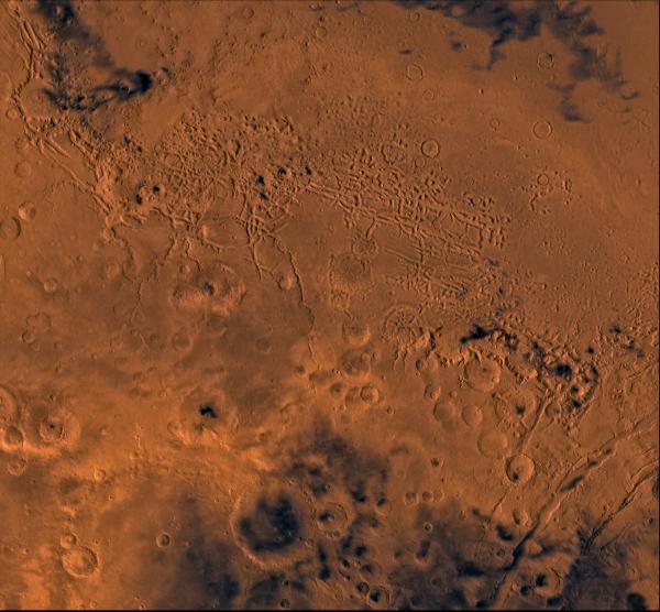
A color image of part of the Nilosyrtis Mensae region of Mars containing the impact craters Antoniadi and Baldet (south to north) in the lower left corner; north toward top. The scene shows heavily cratered highlands on the south separated from the relatively smooth lowland plains on the northeast corner by a belt of dissected terrain, containing flat-floored valleys, mesas, buttes, and channels. The channels are (left to right) Auqakuh and Huo Hsing Valles; Nili Fossae lie in lower right corner of image.
This image is a composite of Viking medium-resolution images in black and white and low-resolution images in color. The image extends from latitude 20 degrees N. to 40 degrees N. and from longitude 280 degrees to 305 degrees. Mercator projection is used below 30 degrees N.; Lambert projection is used above 30 degrees N.
The dissected terrain along the highlands/lowlands boundary consist of the flat-floored valleys (mensae) and farther north the small, rounded hills of knobby terrain. Flows on the mensa floors contain striae that run parallel to valley walls; where valleys meet, the striae merge, similar to medial moraines on glaciers. Terraces within the valley hills have been interpreted as either layer rocks or wave terraces. The knobby terrain has been interpreted as remnants of the old, densely cratered highland terrain perhaps eroded by mass wasting. Auqakuh and Huo Hsing Valles and Nili Fossae are fretted channels and linear depressions that likely formed by sapping and mass wasting along lines of structural weakness.
Cataloging Keywords:
| Name | Value | Additional Values |
|---|---|---|
| Target | Mars | |
| System | ||
| Target Type | Planet | |
| Mission | Viking | |
| Instrument Host | Viking 1 Orbiter | Viking 2 Orbiter |
| Host Type | Orbiter | |
| Instrument | ||
| Detector | ||
| Extra Keywords | Color, Crater, Impact | |
| Acquisition Date | ||
| Release Date | 1998-06-08 | |
| Date in Caption | ||
| Image Credit | NASA/JPL/USGS | |
| Source | photojournal.jpl.nasa.gov/catalog/PIA00417 | |
| Identifier | PIA00417 | |