
|
Scamander Vallis
- Click the image above for a larger view
- Full-Res JPEG (318 x 981) (38.0 kB)
- Full-Res TIFF (318 x 981) (482.3 kB)
Caption:
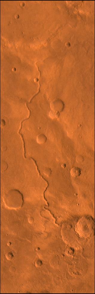
A color image of Scamander Vallis on Mars; north toward top. The scene shows heavily cratered highlands dissected by the slightly sinuous gully of Scamander Vallis. The channel begins by dissecting a steep slope of an impact crater wall and abruptly ends about 180 km north of the crater.
This image is a composite of Viking medium-resolution images in black and white and low-resolution images in color. The image extends from latitude 13 degrees N. to 19 degrees N. and from longitude 330 degrees to 332 degrees; Mercator projection.
The lack of tributaries, fairly straight path, and steep walls of the channel suggest spring sapping as a mode of origin. The abrupt termination may have resulted from burial by younger deposits or perhaps the flows percolated into the surface materials and continued underground.
Cataloging Keywords:
| Name | Value | Additional Values |
|---|---|---|
| Target | Mars | |
| System | ||
| Target Type | Planet | |
| Mission | Viking | |
| Instrument Host | Viking 1 Orbiter | Viking 2 Orbiter |
| Host Type | Orbiter | |
| Instrument | ||
| Detector | ||
| Extra Keywords | Color, Crater, Impact | |
| Acquisition Date | ||
| Release Date | 1998-06-08 | |
| Date in Caption | ||
| Image Credit | NASA/JPL/USGS | |
| Source | photojournal.jpl.nasa.gov/catalog/PIA00419 | |
| Identifier | PIA00419 | |