
|
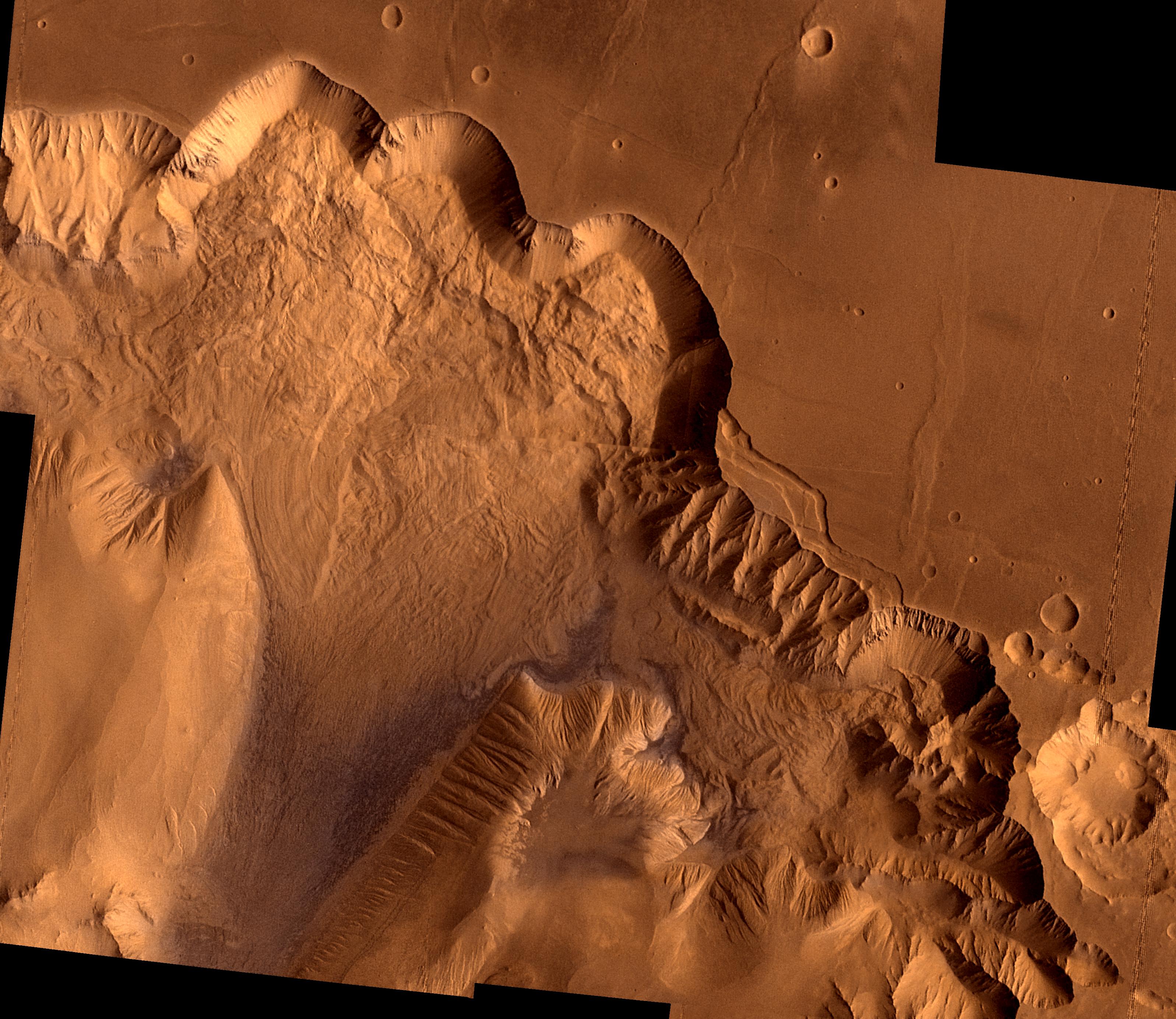
Ophir Chasma
- Click the image above for a larger view
- Full-Res JPEG (3194 x 2769) (1.1 MB)
- Full-Res TIFF (3194 x 2769) (17.8 MB)
Caption:
During its examination of Mars, the Viking 1 spacecraft returned images of Valles Marineris, a huge canyon system 5,000 km long, up to 240 km wide, and 6.5 km deep, whose connected chasma or valleys may have formed from a combination of erosional collapse and structural activity. This synthetic oblique view shows Ophir Chasma, the northern most one of the connected valleys of Valles Marineris; north toward top of frame; for scale, the large impact crater in lower right corner is 30 km (18 miles) wide.
This point-perspective, digital image, centered at latitude 4 degrees S., longitude 71 degrees, is a composite of Viking 1 Orbiter high-resolution (about 80 m/pixel or picture element) images in black and white and low-resolution (about 250 m/pixel) images in color; no vertical exaggeration. The Viking 1 craft landed on Mars in July of 1976.
Ophir Chasma is a large west-northwest-trending trough about 100 km wide. The Chasma is bordered by 4 km high walled cliffs, most likely faults, that show spur-and-gully morphology and smooth sections. The walls have been dissected by landslides forming reentrants; one area (upper left) on the north wall shows a young landslide about 100 km wide. The volume of the landslide debris is more than 1000 times greater than that from the May 18, 1980 debris avalanche from Mount St. Helens. The longitudinal grooves seen in the foreground are thought to be due to differential shear and lateral spreading at high velocities. The landslide passes between mounds of interior layered deposits on the floor of the chasma.
Cataloging Keywords:
| Name | Value | Additional Values |
|---|---|---|
| Target | Mars | |
| System | ||
| Target Type | Planet | |
| Mission | Viking | Mariner |
| Instrument Host | Viking 1 Orbiter | Viking 2 Orbiter |
| Host Type | Orbiter | Flyby Spacecraft |
| Instrument | ||
| Detector | ||
| Extra Keywords | Color, Crater, Impact | |
| Acquisition Date | ||
| Release Date | 1998-06-08 | |
| Date in Caption | 1980-05-18 | |
| Image Credit | NASA/JPL/USGS | |
| Source | photojournal.jpl.nasa.gov/catalog/PIA00425 | |
| Identifier | PIA00425 | |