|
Jupiter’s Icy Satellite Europa
- Click the image above for a larger view
- Full-Res JPEG (1248 x 800) (140.6 kB)
- Full-Res TIFF (1248 x 800) (974.9 kB)
Caption:
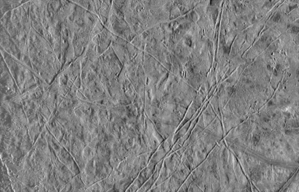
This image of Europa, an icy satellite of Jupiter, was obtained from a range of 39028 miles (62089 kilometers) by the Galileo spacecraft during its fourth orbit around Jupiter and its first close pass of Europa. The image spans an area 157 miles by 244 miles (252 km by 393 km), and shows features as small as a mile (1.6 km) across. Sun illumination is from the right, revealing several ridges crossing the scene, plateaus commonly several miles (10 km) across, and patches of smooth, low-lying darker materials. No prominent impact craters are visible, indicating the surface in this location is not geologically ancient. Some ridges have gaps, and subtle textural differences in these areas indicate that missing ridge segments probably were swept away by volcanic flows. The flow deposits are probably composed mainly of water ice, the chief constituent of the surface of Europa.
Background Info:
The Galileo mission is managed by the Jet Propulsion Laboratory for NASA's Office of Space Science, Washington, D.C.
This image and other images and data received from Galileo are posted on the Galileo mission home page on the World Wide Web at http://galileo.jpl.nasa.gov/ . Background information and educational context for the images can be found at http://www2.jpl.nasa.gov/galileo/sepo/ .
Cataloging Keywords:
| Name | Value | Additional Values |
|---|---|---|
| Target | Europa | Jupiter |
| System | Jupiter | |
| Target Type | Satellite | Planet |
| Mission | Galileo | |
| Instrument Host | Galileo Orbiter | |
| Host Type | Orbiter | |
| Instrument | Solid-State Imaging (SSI) | |
| Detector | ||
| Extra Keywords | Crater, Grayscale, Impact, Volcano, Water | |
| Acquisition Date | ||
| Release Date | 1998-03-06 | |
| Date in Caption | ||
| Image Credit | NASA/JPL/University of Arizona | |
| Source | photojournal.jpl.nasa.gov/catalog/PIA00539 | |
| Identifier | PIA00539 | |