|
Infrared Observations of Europa’s Trailing Side
- Click the image above for a larger view
- Full-Res JPEG (820 x 470) (29.7 kB)
- Full-Res TIFF (820 x 470) (94.4 kB)
Caption:
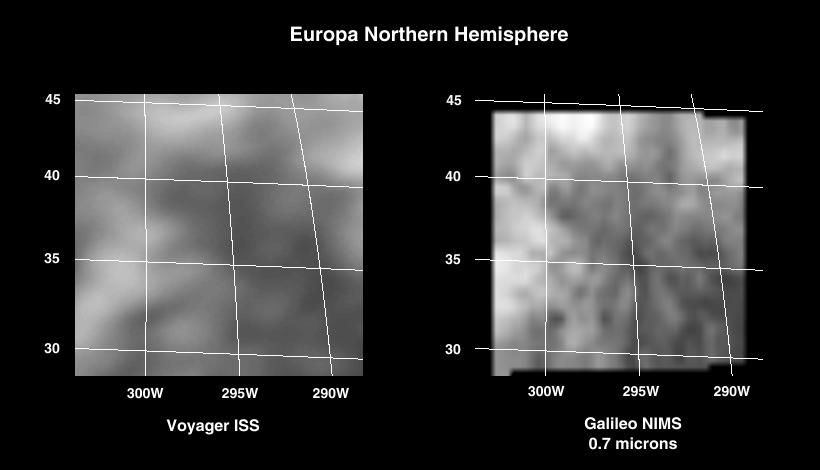
During the first targeted encounter of the icy satellite Europa, the Near Infrared Mapping Spectrometer (NIMS) performed high resolution spectral mapping of the trailing side, a region thought to have minerals other than water ice. For each pixel of the image, there is a corresponding spectrum of several hundred wavelengths which is used to identify the types of material present. The excellent resolution (about 10 km) of the NIMS data shown on the right allows one to isolate the spectral signatures of the different types of terrain, which seem to consist of water frost and hydrated minerals in various proportions. The NIMS image is shown for a wavelength of 0.7 micrometers; a corresponding Voyager image for visible light is shown on the left.
Background Info:
The Jet Propulsion Laboratory, Pasadena, CA manages the mission for NASA's Office of Space Science, Washington, DC.
This image and other images and data received from Galileo are posted on the World Wide Web, on the Galileo mission home page at URL http://galileo.jpl.nasa.gov .
Cataloging Keywords:
| Name | Value | Additional Values |
|---|---|---|
| Target | Europa | |
| System | Jupiter | |
| Target Type | Satellite | |
| Mission | Galileo | Voyager |
| Instrument Host | Galileo Orbiter | |
| Host Type | Orbiter | Flyby Spacecraft |
| Instrument | Near-Infrared Mapping Spectrometer (NIMS) | |
| Detector | ||
| Extra Keywords | Grayscale, Infrared, Water | |
| Acquisition Date | ||
| Release Date | 1998-06-17 | |
| Date in Caption | ||
| Image Credit | NASA/JPL | |
| Source | photojournal.jpl.nasa.gov/catalog/PIA00840 | |
| Identifier | PIA00840 | |