|
Topography on Europa….the Shadow Knows
- Click the image above for a larger view
- Full-Res JPEG (365 x 563) (30.5 kB)
- Full-Res TIFF (365 x 563) (199.6 kB)
Caption:
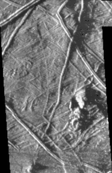
This image of Europa was taken by the Galileo spacecraft under "low-sun" illumination--the equivalent of taking a picture from a high altitude at sunrise or sunset. Note that in this image the topography of the terrain is emphasized. Planetary geologists use information from images acquired under a variety of lighting conditions to identify different types of structures and interpret how they formed. For example, the length of the shadow cast by a feature (e.g. a ridge or knob) is indicative of that feature's height. In this recent image, ridges and irregularly shaped knobs ranging in size from 5 kilometers across down to the limit of resolution (0.44 kilometers/pixel) can be seen. Measurements from shadow lengths indicate that features in this image range from tens of meters up to approximately one hundred meters in height.
The Galileo spacecraft acquired this image of Europa's surface during its third orbit around Jupiter. The image covers an area approximately 40 kilometers (25 miles) by 75 kilometers (45 miles), centered near 10S, 190W.
Background Info:
The Jet Propulsion Laboratory, Pasadena, CA manages the mission for NASA's Office of Space Science, Washington, DC.
This image and other images and data received from Galileo are posted on the World Wide Web, on the Galileo mission home page at URL http://galileo.jpl.nasa.gov.
Cataloging Keywords:
| Name | Value | Additional Values |
|---|---|---|
| Target | Europa | Jupiter |
| System | Jupiter | |
| Target Type | Satellite | Planet |
| Mission | Galileo | |
| Instrument Host | Galileo Orbiter | |
| Host Type | Orbiter | |
| Instrument | Solid-State Imaging (SSI) | |
| Detector | ||
| Extra Keywords | Grayscale, Shadow | |
| Acquisition Date | ||
| Release Date | 1997-12-18 | |
| Date in Caption | ||
| Image Credit | NASA/JPL | |
| Source | photojournal.jpl.nasa.gov/catalog/PIA01101 | |
| Identifier | PIA01101 | |