|
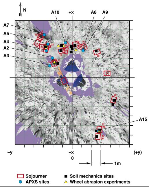
Overhead View of Area Surrounding Pathfinder
- Click the image above for a larger view
- Full-Res JPEG (973 x 1219) (197.0 kB)
- Full-Res TIFF (973 x 1219) (1.0 MB)
Caption:
Overhead view of the area surrounding the Pathfinder lander illustrating the Sojourner traverse. Red rectangles are rover positions at the end of sols 1-30. Locations of soil mechanics experiments, wheel abrasion experiments, and APXS measurements are shown. The A numbers refer to APXS measurements as discussed in the paper by Rieder et al. (p. 1770, Science Magazine, see image note). Coordinates are given in the LL frame.
The photorealistic, interactive, three-dimensional virtual reality (VR) terrain models were created from IMP images using a software package developed for Pathfinder by C. Stoker et al. as a participating science project. By matching features in the left and right camera, an automated machine vision algorithm produced dense range maps of the nearfield, which were projected into a three-dimensional model as a connected polygonal mesh. Distance and angle measurements can be made on features viewed in the model using a mouse-driven three-dimensional cursor and a point-and-click interface. The VR model also incorporates graphical representations of the lander and rover and the sequence and spatial locations at which rover data were taken. As the rover moved, graphical models of the rover were added for each position that could be uniquely determined using stereo images of the rover taken by the IMP. Images taken by the rover were projected into the model as two-dimensional "billboards" to show the proper perspective of these images.
NOTE: original caption as published in Science magazine
Background Info:
Mars Pathfinder is the second in NASA's Discovery program of low-cost spacecraft with highly focused science goals. The Jet Propulsion Laboratory, Pasadena, CA, developed and manages the Mars Pathfinder mission for NASA's Office of Space Science, Washington, D.C. JPL is a division of the California Institute of Technology (Caltech).
Photojournal note: Sojourner spent 83 days of a planned seven-day mission exploring the Martian terrain, acquiring images, and taking chemical, atmospheric and other measurements. The final data transmission received from Pathfinder was at 10:23 UTC on September 27, 1997. Although mission managers tried to restore full communications during the following five months, the successful mission was terminated on March 10, 1998.
Cataloging Keywords:
| Name | Value | Additional Values |
|---|---|---|
| Target | Mars | |
| System | ||
| Target Type | Planet | |
| Mission | Mars Pathfinder (MPF) | |
| Instrument Host | Mars Pathfinder Lander | |
| Host Type | Lander | |
| Instrument | Imager for Mars Pathfinder (IMP) | |
| Detector | ||
| Extra Keywords | Atmosphere, Color | |
| Acquisition Date | ||
| Release Date | 1998-03-26 | |
| Date in Caption | ||
| Image Credit | NASA/JPL/USGS | |
| Source | photojournal.jpl.nasa.gov/catalog/PIA01151 | |
| Identifier | PIA01151 | |