|
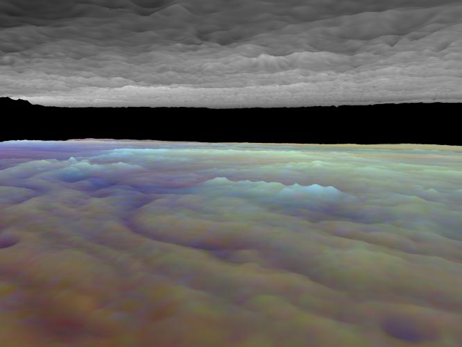
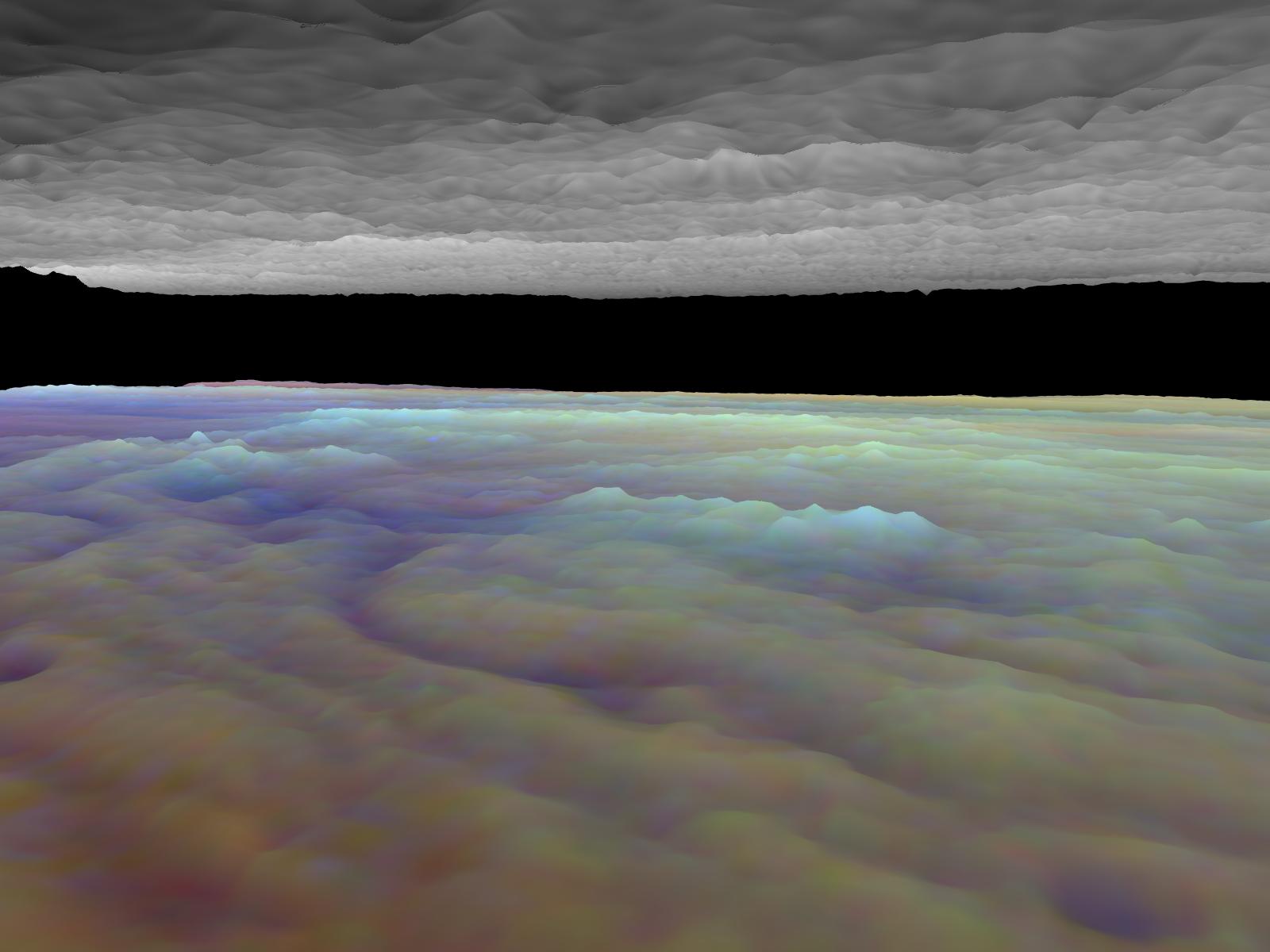
Three dimensional Visualization of Jupiter’s Equatorial Region
- Click the image above for a larger view
- Full-Res JPEG (1600 x 1200) (101.0 kB)
- Full-Res TIFF (1600 x 1200) (3.1 MB)
Caption:
Frames from a three dimensional visualization of Jupiter's equatorial region. The images used cover an area of 34,000 kilometers by 11,000 kilometers (about 21,100 by 6,800 miles) near an equatorial "hotspot" similar to the site where the probe from NASA's Galileo spacecraft entered Jupiter's atmosphere on December 7th, 1995. These features are holes in the bright, reflective, equatorial cloud layer where warmer thermal emission from Jupiter's deep atmosphere can pass through. The circulation patterns observed here along with the composition measurements from the Galileo Probe suggest that dry air may be converging and sinking over these regions, maintaining their cloud-free appearance. The bright clouds to the right of the hotspot as well as the other bright features may be examples of upwelling of moist air and condensation.
This frame is a view to the southeast, from between the cloud layers and over the north center of the region. The tall white clouds in the lower cloud deck are probably much like large terrestrial thunderclouds. They may be regions where atmospheric water powers vertical convection over large horizontal distances.
Galileo is the first spacecraft to image Jupiter in near-infrared light (which is invisible to the human eye) using three filters at 727, 756, and 889 nanometers (nm). Because light at these three wavelengths is absorbed at different altitudes by atmospheric methane, a comparison of the resulting images reveals information about the heights of clouds in Jupiter's atmosphere. This information can be visualized by rendering cloud surfaces with the appropriate height variations.
The visualization reduces Jupiter's true cloud structure to two layers. The height of a high haze layer is assumed to be proportional to the reflectivity of Jupiter at 889 nm. The height of a lower tropospheric cloud is assumed to be proportional to the reflectivity at 727 nm divided by that at 756 nm. This model is overly simplistic, but is based on more sophisticated studies of Jupiter's cloud structure. The upper and lower clouds are separated in the rendering by an arbitrary amount, and the height variations are exaggerated by a factor of 25.
The lower cloud is colored using the same false color scheme used in previously released image products, assigning red, green, and blue to the 756, 727, and 889 nanometer mosaics, respectively. Light bluish clouds are high and thin, reddish clouds are low, and white clouds are high and thick. The dark blue hotspot in the center is a hole in the lower cloud with an overlying thin haze.
The images used cover latitudes 1 to 10 degrees and are centered at longitude 336 degrees west. The smallest resolved features are tens of kilometers in size. These images were taken on December 17, 1996, at a range of 1.5 million kilometers (about 930,000 miles) by the Solid State Imaging (CCD) system on NASA's Galileo spacecraft.
Background Info:
The Jet Propulsion Laboratory, Pasadena, CA manages the Galileo mission for NASA's Office of Space Science, Washington, DC. JPL is an operating division of California Institute of Technology (Caltech).
This image and other images and data received from Galileo are posted on the World Wide Web, on the Galileo mission home page at URL http://www.jpl.nasa.gov/ galileo.
Cataloging Keywords:
| Name | Value | Additional Values |
|---|---|---|
| Target | Jupiter | |
| System | Jupiter | |
| Target Type | Planet | |
| Mission | Galileo | |
| Instrument Host | Galileo Orbiter | Galileo Probe |
| Host Type | Orbiter | Probe |
| Instrument | Solid-State Imaging (SSI) | |
| Detector | ||
| Extra Keywords | Atmosphere, Color, Haze, Infrared, Methane, Thermal, Water | |
| Acquisition Date | ||
| Release Date | 1998-03-06 | |
| Date in Caption | 1996-12-17 | |
| Image Credit | NASA/JPL-Caltech | |
| Source | photojournal.jpl.nasa.gov/catalog/PIA01193 | |
| Identifier | PIA01193 | |