
|
Near-Terminator Image of Europa
- Click the image above for a larger view
- Full-Res JPEG (800 x 800) (67.8 kB)
- Full-Res TIFF (800 x 800) (353.1 kB)
Caption:
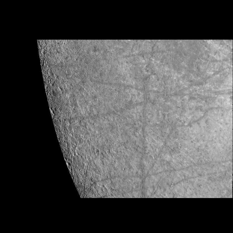
This image of Europa's surface was obtained by the Solid State Imaging (CCD) system on board NASA's Galileo spacecraft during its fourth orbit of Jupiter, Linear features with bright central stripes referred to as "triple bands" are seen to transect the surface of Europa. Several of these triple bands are over 700 kilometers in length. In the left side of the image the surface of Europa is seen to be locally pitted and irregular. Ridges less than 100 kilometers in length are also visible in this region.
The area seen in this image, centered near 27 degrees South, 300 degrees West, is 760 kilometers (456 miles) by 850 kilometers (510 miles) across, which is approximately the size of the state of Texas or the country of France. North is to the top of the image, with the sun illuminating the surface from the left. The image which has a resolution of 1.3 kilometers per picture element (pixel) was obtained on December 19th, 1996 (Universal Time).
Background Info:
The Jet Propulsion Laboratory, Pasadena, CA manages the mission for NASA's Office of Space Science, Washington, DC.
This image and other images and data received from Galileo are posted on the World Wide Web, on the Galileo mission home page at URL http://galileo.jpl.nasa.gov. Background information and educational context for the images can be found at http://www.jpl.nasa.gov/galileo/sepo .
Cataloging Keywords:
| Name | Value | Additional Values |
|---|---|---|
| Target | Europa | Jupiter |
| System | Jupiter | |
| Target Type | Satellite | Planet |
| Mission | Galileo | |
| Instrument Host | Galileo Orbiter | |
| Host Type | Orbiter | |
| Instrument | Solid-State Imaging (SSI) | |
| Detector | ||
| Extra Keywords | Grayscale | |
| Acquisition Date | ||
| Release Date | 1998-03-06 | |
| Date in Caption | ||
| Image Credit | NASA/JPL/University of Arizona | |
| Source | photojournal.jpl.nasa.gov/catalog/PIA01212 | |
| Identifier | PIA01212 | |