|
Topography of Io
- Click the image above for a larger view
- Full-Res JPEG (410 x 460) (30.4 kB)
- Full-Res TIFF (410 x 460) (150.0 kB)
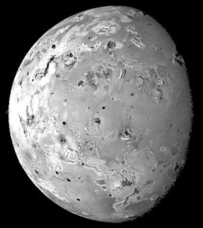
Caption:
This image of Io was acquired by Galileo during its ninth orbit (C9) of Jupiter as part of a sequence of images designed to cover Io at low illumination angles to map the landforms. Obtaining images at such illuminations is like taking a picture from a high altitude around sunrise or sunset. Such lighting conditions emphasize the topography of the volcanic satellite. Several mountains up to a few miles high can be seen in this view, especially near the upper right. Some of these mountains appear to be tilted crustal blocks.
North is to the top of the picture. The resolution is 8.3 kilometers per picture element. The image was taken on June 27, 1997 at a range of 817,000 kilometers by the solid state imaging (CCD) system on NASA's Galileo spacecraft.
Background Info:
The Jet Propulsion Laboratory, Pasadena, CA manages the mission for NASA's Office of Space Science, Washington, DC.
This image and other images and data received from Galileo are posted on the World Wide Web, on the Galileo mission home page at URL http://galileo.jpl.nasa.gov. Background information and educational context for the images can be found at http://www.jpl.nasa.gov/galileo/sepo .
Cataloging Keywords:
| Name | Value | Additional Values |
|---|---|---|
| Target | Io | Jupiter |
| System | Jupiter | |
| Target Type | Satellite | Planet |
| Mission | Galileo | |
| Instrument Host | Galileo Orbiter | |
| Host Type | Orbiter | |
| Instrument | Solid-State Imaging (SSI) | |
| Detector | ||
| Extra Keywords | Grayscale, Map, Mountain, Volcano | |
| Acquisition Date | ||
| Release Date | 1998-03-26 | |
| Date in Caption | 1997-06-27 | |
| Image Credit | NASA/JPL/University of Arizona | |
| Source | photojournal.jpl.nasa.gov/catalog/PIA01217 | |
| Identifier | PIA01217 | |