|
Lava Flows On Ascraeus Mons Volcano
- Click the image above for a larger view
- Full-Res JPEG (800 x 800) (63.9 kB)
- Full-Res TIFF (800 x 800) (419.7 kB)
Caption:
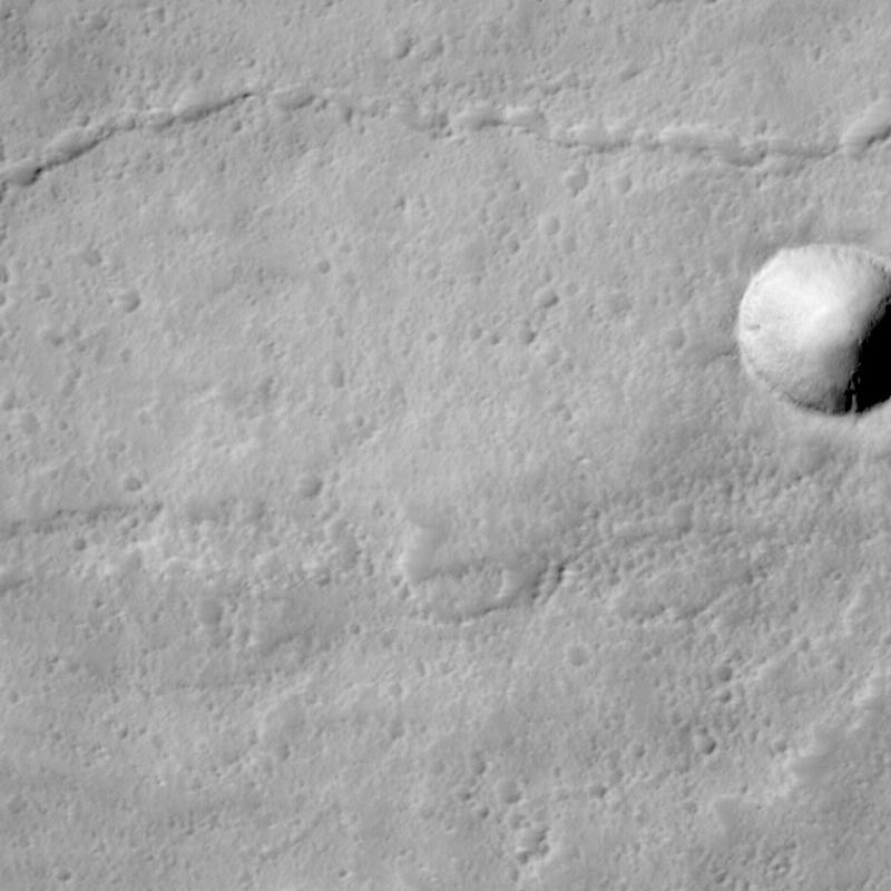
Ascraeus Mons Volcano:
Like Earth, Mars has many volcanoes and volcanic features. This high-resolution view shows some of the lava flows near the summit of Ascraeus Mons, one of the three giant
shield volcanoes
known as the "Tharsis Montes." Volcanoes form when
magma
(molten rock) erupts out onto the surface of a planet. Based on Viking-era observations, Ascraeus Mons is considered to be one of the tallest volcanoes on Mars... its summit is more than 11 km (6.8 miles) above the surrounding plain. The summit is more than 23 km (14 miles) higher in elevation than the place where Mars Pathfinder landed in July 1997.
Description of MOC Image:
This picture shows an area that is about 20 km (12 miles) higher in elevation than the Mars Pathfinder landing site. The picture shows three main features: (1) a crater at the center-right, (2) a sinuous, discontinuous channel across the upper half, and (3) a rough and pitted, elevated surface across the lower half of the image.
(1) Crater at center right. Distinguishing meteor craters from volcanic craters can sometimes be a challenge on Mars. This particular crater was most likely formed by meteor impact because it has a raised rim and a faint radial ejecta pattern around the outside of it. This crater is 600 m (2000 feet) across, about 3/4 the size of the famous "Meteor Crater" near Winslow, Arizona.
(2) Sinuous channel. The type of discontinuous channel running across the upper half of the image is sometimes referred to as a "sinuous rille." These are common on the volcanic plains of the Moon and among volcanoes and volcanic plains on Earth. Such a channel was once a lava tube. It is running down the middle of an old lava flow. The "tube" looks like a "channel" because its roof has collapsed. The discontinuous nature of this channel is the result of the collapse, or "cave-in" of what was once the roof of the lava tube. It is common for certain types of relatively fluid lavas to form lava tubes. As it is being emplaced, the outer margins of the lava flow cool and harden, but the interior remains hot and continues to flow down-hill. Eventually, the eruption stops and the lava inside the tube cools, contracts, and hardens, leaving behind a tube (basically, a long narrow cave).
(3) Rough elevated surface. The rough, pitted, and elevated surface across the bottom half of the image is a lava flow. The margins of this feature are somewhat lobate in form, and the entire feature is elevated above its surroundings, indicating that it was the last lava flow to pour through this region.
Putting it All Together: Aa and Pahoehoe Lava Flows:
Shield volcanoes such as Ascraeus Mons form from relatively fluid lavas. Shield volcanoes on Earth include the well-known Islands of Hawai'i. The kind of lava that is fluid enough to make shield volcanoes is called
basalt.
This is an iron- and magnesium-rich silicate lava that, when cooled, is usually black or very dark brown.
Basalt lava flows come in two main varieties: Aa i> and Pahoehoe. These are Hawai'ian names. "Aa" (pronounced "ah-ah") lava flows have very rough, jumbly surfaces, and they usually lack lava tubes. "Aa" lava flow surfaces are very rough to walk on-- thus the term "aa" probably refers to the sound a person might make when walking on a cooled/solidified aa flow in bare feet!
"Pahoehoe" (pronounced "pa-hoy-hoy") is a term that means "ropey." The surfaces of pahoehoe lava flows are generally very smooth and billowy. Sometimes they have a ropy texture like melted taffy or caramel. Pahoehoe flows very commonly contain lava tubes.
The rough-surfaced flow across the lower half of the MOC image is interpreted to be an "aa" lava flow, and the smoother surface with a sinuous channel running down its center is interpreted to be a "pahoehoe" lava flow. Both would indicate that the lavas on Ascraeus Mons, at least at this location, are probably composed of basalt.
More Picture Information:
This MOC picture is a subframe of image #26705, centered approximately at 11.5°N latitude, 103.5°W longitude. It was taken on April 28, 1998, at 4:23 AM Universal Time, on Mars Global Surveyor's 267th orbit around Mars. Orbit 267 was the second-to-last orbit on which observations were obtained before Mars and the spacecraft passed behind the Sun for several weeks known as "Solar Conjunction."
Background Info:
Malin Space Science Systems and the California Institute of Technology built the MOC using spare hardware from the Mars Observer mission. MSSS operates the camera from its facilities in San Diego, CA. The Jet Propulsion Laboratory's Mars Surveyor Operations Project operates the Mars Global Surveyor spacecraft with its industrial partner, Lockheed Martin Astronautics, from facilities in Pasadena, CA and Denver, CO.http://www.jpl.nasa.gov/galileo/sepo
Cataloging Keywords:
| Name | Value | Additional Values |
|---|---|---|
| Target | Mars | |
| System | ||
| Target Type | Planet | |
| Mission | Mars Global Surveyor (MGS) | Mars Pathfinder (MPF), Viking |
| Instrument Host | Mars Global Surveyor | |
| Host Type | Orbiter | |
| Instrument | Mars Orbiter Camera (MOC) | |
| Detector | ||
| Extra Keywords | Crater, Dust, Grayscale, Impact, Moon, Mountain, Volcano | |
| Acquisition Date | ||
| Release Date | 1998-06-15 | |
| Date in Caption | 1998-04-28 | |
| Image Credit | NASA/JPL/MSSS | |
| Source | photojournal.jpl.nasa.gov/catalog/PIA01431 | |
| Identifier | PIA01431 | |