
|
Mars Pathfinder First Anniversary Special – Refined Landing Site Location
- Click the image above for a larger view
- Full-Res JPEG (1385 x 1024) (289.2 kB)
- Full-Res TIFF (1385 x 1024) (2.3 MB)
Caption:
It has been one year since NASA's Return to the Red Planet began with the spectacular landing of Mars Pathfinder and its microrover, Sojourner. The spacecraft bounced onto a flood-washed landscape on July 4, 1997.
Mars Pathfinder was soon joined by the orbiting Mars Global Surveyor on September 11, 1997 (PDT). Mars Global Surveyor's high resolution camera, MOC, took a picture of the Mars Pathfinder landing site region during its 256th orbit on April 22, 1998. This picture--at about 5 meters (11 feet) per pixel--is the best available for the site. The previous best images were from the Viking 1 Orbiter in 1976, and had resolutions of about 38 meters (125 feet) per pixel.
The MOC image has allowed scientists to determine the exact location of the Mars Pathfinder lander. Unfortunately, the image resolution is not good enough to actually see the lander--nor can any of the familiar boulders (e.g., "Yogi") be seen at this resolution.
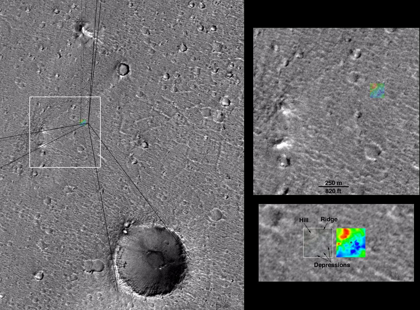
Using the MOC image, the landing site location has been refined by Dr. Michael Malin, Principal Investigator for the Mars Global Surveyor MOC Team and a Participating Scientist on the Mars Pathfinder mission. The images above illustrate how the landing site was located by using the "sight lines" published by T. Parker (Jet Propulsion Laboratory, Pasadena, CA) and topographic map provided by R. Kirk (U.S. Geological Survey, Flagstaff, AZ).
Left image: MOC image 25603 subframe, shown at 15 meters (about 50 feet) per pixel resolution. Small, colored box is a topographic map of the Mars Pathfinder landing site produced by the U.S. Geological Survey (Flagstaff, AZ) from Mars Pathfinder stereographic images . Dark, heavy lines are "sight lines" to various landmarks seen along the horizon in Mars Pathfinder camera images, measured by T. Parker and matched to features seen in Viking Orbiter images. These lines were published in Science, v. 278, p. 1746, December 5, 1997. The lighter, thinner sightlines are the same lines, adjusted to match the same features as seen in the higher resolution MOC image 25603. These lines indicate the location of the landing site to within a few hundred meters/yards. The colored box--the topographic map--has been placed at the location of the actual landing site. The lander and rover would be located at the center of the colored box. The white box shows the context of the image to the right. North is up, illumination is from the lower right.
Top right image: Location of Mars Pathfinder lander and Sojourner Rover, relative to Mars Global Surveyor MOC image obtained April 1998. The famous "Twin Peaks"-- first seen by the lander on July 4, 1997--are shown at the lower left. The scale bar indicates distance in feet and in meters. The colored box is the topographic map of the Mars Pathfinder landing site, derived from Pathfinder camera stereoscopic images by R. Kirk and colleagues. The lander and rover were located in the center of the colored box.
Bottom right image: Location of Mars Pathfinder landing site in MOC image 25603. The lander is located in the center of the white box. The original resolution of the MOC image was about 3.3 meters (11 feet) per pixel; however, because the region was hazy at the time the picture was taken, the effective resolution is only about 5 meters (16.4 feet) per pixel. Thus, the lander and rover are too small to actually be seen in the image. The colored box, 120 m (just under 400 ft) on a side, is the topographic map of the landing site. The topographic map was made using the stereographic images taken by Mars Pathfinder in 1997. Low areas-- depressions--are blue and purple, high areas--hill--are shown as red. The range of heights is actually fairly small--a total of 4 m (about 13 ft) from dark purple to bright red. The lander is represented within the black dot at the center of the map. A preliminary version of the topographic map that is generally similar to this more refined version was published in Science, v. 278, p. 1736, December 5, 1997.
Background Info:
Malin Space Science Systems and the California Institute of Technology built the MOC using spare hardware from the Mars Observer mission. MSSS operates the camera from its facilities in San Diego, CA. The Jet Propulsion Laboratory's Mars Surveyor Operations Project operates the Mars Global Surveyor spacecraft with its industrial partner, Lockheed Martin Astronautics, from facilities in Pasadena, CA and Denver, CO.
Cataloging Keywords:
| Name | Value | Additional Values |
|---|---|---|
| Target | Mars | |
| System | ||
| Target Type | Planet | |
| Mission | Mars Global Surveyor (MGS) | Mars Pathfinder (MPF), Viking |
| Instrument Host | Mars Global Surveyor | Viking 1 Orbiter |
| Host Type | Orbiter | |
| Instrument | Mars Orbiter Camera (MOC) | |
| Detector | ||
| Extra Keywords | Atmosphere, Color, Dust, Haze, Map | |
| Acquisition Date | ||
| Release Date | 1998-07-03 | |
| Date in Caption | 1997-07-04 | 1997-09-11, 1997-12-05, 1998-04-22 |
| Image Credit | NASA/JPL/Malin Space Science Systems | |
| Source | photojournal.jpl.nasa.gov/catalog/PIA01447 | |
| Identifier | PIA01447 | |