
|
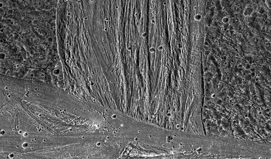
Swaths of Grooved Terrain on Ganymede
- Click the image above for a larger view
- Full-Res JPEG (949 x 559) (160.6 kB)
- Full-Res TIFF (949 x 559) (499.9 kB)
Caption:
A swath of grooved terrain named Erech Sulcus cuts north-south across the ancient dark terrain of Marius Regio. The multiple scales of ubiquitous grooves in Erech Sulcus probably formed when tectonic forces pulled apart the icy surface of Jupiter's moon, Ganymede. Similar sets of faults occur in rift zones on Earth, as in eastern Africa. The southern edge of Erech Sulcus is truncated by the smoother bright terrain of Sippar Sulcus, trending roughly east-west. The relatively smooth appearance of Sippar Sulcus hints that icy volcanism once paved over the area.
North is to the top of the picture and the sun illuminates the surface from the right. The mosaic, centered at 16 degrees south latitude and 177 degrees longitude, covers an area approximately 950 by 560 kilometers. The resolution is 143 meters per picture element. The images were taken on May 7, 1997 at 15 hours, 24 minutes, 39 seconds Universal Time at a range of 14,263 kilometers by the Solid State Imaging (SSI) system on NASA's Galileo spacecraft.
Background Info:
The Jet Propulsion Laboratory, Pasadena, CA manages the Galileo mission for NASA's Office of Space Science, Washington, DC.
This image and other images and data received from Galileo are posted on the World Wide Web, on the Galileo mission home page at URL http://solarsystem.nasa.gov/galileo/ . Background information and educational context for the images can be found at http://www.jpl.nasa.gov/galileo/sepo .
Cataloging Keywords:
| Name | Value | Additional Values |
|---|---|---|
| Target | Ganymede | |
| System | Jupiter | |
| Target Type | Satellite | |
| Mission | Galileo | |
| Instrument Host | Galileo Orbiter | |
| Host Type | Orbiter | |
| Instrument | Solid-State Imaging (SSI) | |
| Detector | ||
| Extra Keywords | Grayscale, Volcano | |
| Acquisition Date | ||
| Release Date | 1998-07-15 | |
| Date in Caption | 1997-05-07 | |
| Image Credit | NASA/JPL/Brown University | |
| Source | photojournal.jpl.nasa.gov/catalog/PIA01615 | |
| Identifier | PIA01615 | |