|
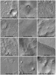
Mars Surfaces at 15.6°N Latitude, March 1999
- Click the image above for a larger view
- Full-Res JPEG (788 x 1048) (141.3 kB)
- Full-Res TIFF (788 x 1048) (755.0 kB)
Caption:
This set of 12 images was obtained during the period of Mars Orbiter Camera (MOC) focus tests and calibrations that executed in the first week of March 1999. Each picture was taken near 15.6°N latitude, which at this time was the sub-Earth point—the latitude at which Earth would be seen directly overhead if viewed from the ground. These pictures were obtained to provide a direct link between simultaneous Earth- and space-based telescope observations and the MOC. Each picture is shown at the full commanded resolution of 12 meters (39 feet) per pixel, and each covers an area 3 by 3 kilometers (1.9 miles) in size with illumination from the upper left. Typically, images that will be obtained by MOC during the Mapping Phase of the Mars Global Surveyor mission will have resolutions of 1.5 meters (5 feet) per pixel—a factor of 8 improvement over the pictures shown here.
Background Info:
Malin Space Science Systems and the California Institute of Technology built the MOC using spare hardware from the Mars Observer mission. MSSS operates the camera from its facilities in San Diego, CA. The Jet Propulsion Laboratory's Mars Surveyor Operations Project operates the Mars Global Surveyor spacecraft with its industrial partner, Lockheed Martin Astronautics, from facilities in Pasadena, CA and Denver, CO.
Cataloging Keywords:
| Name | Value | Additional Values |
|---|---|---|
| Target | Mars | |
| System | ||
| Target Type | Planet | |
| Mission | Mars Global Surveyor (MGS) | |
| Instrument Host | Mars Global Surveyor | |
| Host Type | Orbiter | |
| Instrument | Mars Orbiter Camera (MOC) | |
| Detector | ||
| Extra Keywords | Dust, Grayscale | |
| Acquisition Date | ||
| Release Date | 2000-09-18 | |
| Date in Caption | ||
| Image Credit | NASA/JPL/MSSS | |
| Source | photojournal.jpl.nasa.gov/catalog/PIA01672 | |
| Identifier | PIA01672 | |
