|
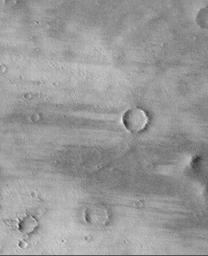
Wind Streaks on Daedalia Planum
- Click the image above for a larger view
- Full-Res JPEG (1006 x 1240) (161.6 kB)
- Full-Res TIFF (1006 x 1240) (1.1 MB)
Caption:
Daedalia Planum is a broad, wind-swept volcanic plain southwest of the Arsia Mons volcano. Since the 1972 Mariner 9 mission, this region has been known to have many wind streaks formed in the lee of obstacles (i.e., downwind of craters and hills) as wind blows loose sediment through the region. Here, the wind streaks are a combination of bright surfaces (where sand and/or dust has accumulated) and dark surfaces (where sand and/or dust has been removed). The streaks indicate wind blowing from right to left. Other evidence of wind action is found in the form of many parallel ridges and grooves that run diagonally across the scene--these probably formed by wind erosion at an earlier time when the wind was blowing from a direction different from that indicated by the bright and dark streaks. This picture was taken by the Mars Orbiter Camera (MOC) onboard the Mars Global Surveyor (MGS) and is illuminated from the left. The picture covers an area about 7.6 km (4.7 miles) by 9.3 km (5.8 miles).
Background Info:
Malin Space Science Systems and the California Institute of Technology built the MOC using spare hardware from the Mars Observer mission. MSSS operates the camera from its facilities in San Diego, CA. The Jet Propulsion Laboratory's Mars Surveyor Operations Project operates the Mars Global Surveyor spacecraft with its industrial partner, Lockheed Martin Astronautics, from facilities in Pasadena, CA and Denver, CO.
Cataloging Keywords:
| Name | Value | Additional Values |
|---|---|---|
| Target | Mars | |
| System | ||
| Target Type | Planet | |
| Mission | Mars Global Surveyor (MGS) | Mariner |
| Instrument Host | Mars Global Surveyor | |
| Host Type | Orbiter | Flyby Spacecraft |
| Instrument | Mars Orbiter Camera (MOC) | |
| Detector | ||
| Extra Keywords | Crater, Dust, Grayscale, Mountain, Volcano | |
| Acquisition Date | ||
| Release Date | 1999-03-29 | |
| Date in Caption | ||
| Image Credit | NASA/JPL/MSSS | |
| Source | photojournal.jpl.nasa.gov/catalog/PIA01690 | |
| Identifier | PIA01690 | |
