|
Head of Chasma Boreale Near Mars’ North Pole
- Click the image above for a larger view
- Full-Res JPEG (9687 x 4320) (3.7 MB)
- Full-Res TIFF (9687 x 4320) (41.9 MB)
Caption:
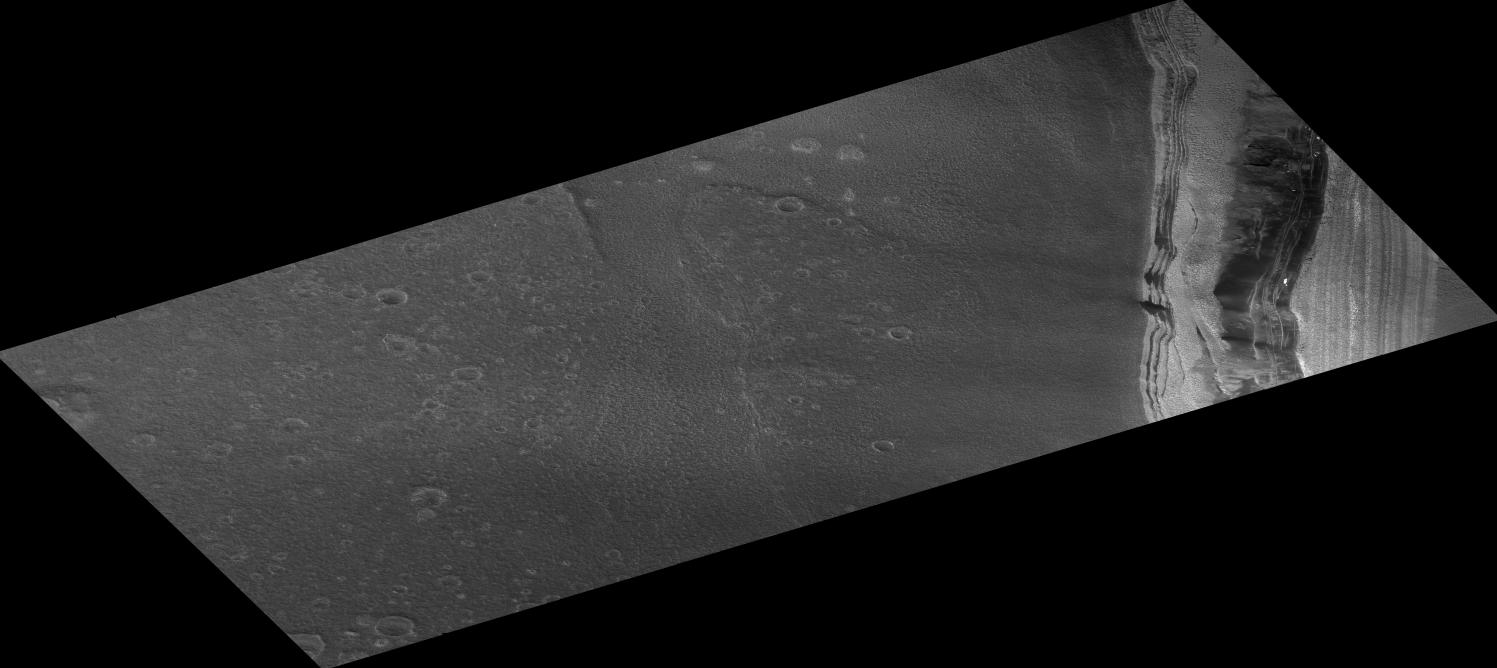
The Martian terrain in this remarkable image is at the head of a large chasm, named Chasma Boreale, which cuts through Mars' north polar layered deposits. These ice-rich layered deposits are about 3,000 meters (9,800 feet) thick and 1,000 kilometers (1,600 miles) across, much like the Greenland ice-sheet on Earth. The head of Chasma Boreale ends in a steep icy cliff more than 1,000 meters (3,300 feet) high. The cliff has both light- and dark-toned layers, seen at right in this image. The image was taken by the High Resolution Imaging Science Experiment (HiRISE) camera on NASA's Mars Reconnaissance Orbiter. The internal layers of the ice-sheet are visible in the cliff walls. The dark-toned flat area in the center and left of the image is the floor of this chasm, which contains many craters.
Scientists have proposed that Chasma Boreale was formed by a catastrophic flood that began under the ice-sheet and was later widened by wind erosion. However, the large number of craters on the chasm's floor implies that the floor is much older than the ice sheet. These craters should have been removed by the suggested flood; their presence has caused some Mars researchers to instead speculate that no large flood occurred and that Chasma Boreale was not covered with very much ice.
In addition to layered ice, there is also some material within the north polar layered deposits that appears to be composed of sand. The dark material near the base of the cliff wall is thought to be aprons of debris being eroded from sand-rich layers. Zooming in on this dark material with HiRISE reveals ripples, which are diagnostic of moving sand.
Some bright spots of material visible on the cliff wall were not present in previous years. These are likely patches of water frost. Each year layers of carbon dioxide and water frost coat this terrain before being removed during the summer. The water frost lasts longer, and patches that are shaded by nearby steep topography (such as this one) can persist even into late summer.
An unexpected surprise, not visible with previous camera resolutions, is the fragmentation of the exposed surfaces of these icy layers into polygonal blocks. These blocks appear to be breaking away from the layer margins and forming boulder-sized debris, which then rolls down slope (a process called mass-wasting). These boulders are likely to be large blocks of dusty water ice; once separated from the main ice-sheet they can be eroded away by sunlight. More boulder-sized objects are visible out in the floor of the chasm. Polygons are also visible throughout the chasm floor, indicating that water-ice is just below the surface.
Image TRA_000845_2645 was taken by the HiRISE camera on Oct. 1, 2006. The complete image is centered at 84.6 degrees latitude, 3.4 degrees east longitude. The range to the target site was 316 kilometers (198 miles). At this distance the image scale is 63 centimeters (25 inches) per pixel (with 2 x 2 binning), so objects about 186 centimeters (73 inches) across are resolved. The image shown here has been map-projected to 50 centimeters (20 inches) per pixel. North is up. The image was taken at a local Mars time of 3:34 p.m. and the scene is illuminated from the west with a solar incidence angle of 62.3 degrees, thus the sun was about 27.7 degrees above the horizon. At a solar longitude of 114.3 degrees, the season on Mars is northern summer.
The full-resolution TIFF file (HiRISE number TRA_000845_2645) can be viewed or downloaded here PIA01926-hi-res.tif ; the full-resolution JPEG can be viewed or downloaded here PIA01926-hi-res.jpg . [Photojournal note: due to the large sizes of the high-resolution TIFF and JPEG files, some systems may experience extremely slow downlink time while viewing or downloading these images; some systems may be incapable of handling the download entirely.]
Cataloging Keywords:
| Name | Value | Additional Values |
|---|---|---|
| Target | Mars | |
| System | ||
| Target Type | Planet | |
| Mission | Mars Reconnaissance Orbiter (MRO) | |
| Instrument Host | Mars Reconnaissance Orbiter | |
| Host Type | Orbiter | |
| Instrument | High Resolution Imaging Science Experiment (HiRISE) | |
| Detector | ||
| Extra Keywords | Crater, Dust, Grayscale, Map, Water | |
| Acquisition Date | ||
| Release Date | 2006-10-16 | |
| Date in Caption | 2006-10-01 | |
| Image Credit | NASA/JPL/Univ. of Arizona | |
| Source | photojournal.jpl.nasa.gov/catalog/PIA01926 | |
| Identifier | PIA01926 | |