|
Temperature of the Martian Surface
- Click the image above for a larger view
- Full-Res JPEG (2362 x 1667) (434.8 kB)
- Full-Res TIFF (2362 x 1667) (1.2 MB)
Caption:
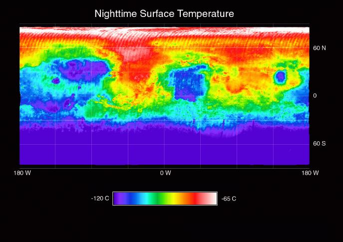
This image shows the nighttime (2 AM) temperature of the Martian surface as measured by the Thermal Emission Spectrometer (TES) instrument on the Mars Global Surveyor. The data were acquired during the first 500 orbits of the MGS mapping mission. The coldest temperatures (shown in purple) are -120C and the warmest temperatures (white) are -65C. The pattern of nighttime temperature in the equatorial region indicates variations in the particle size of the surface materials.
The coldest regions are areas of very fine (dust) grains, while the warmest regions are areas of coarse sand, gravel, and rocks. Valles Marineris (~-10S, 30-90W) and the channels leading into Acidalia Planitia and the Pathfinder landing site (5-20N; 20-45W) are clearly visible as regions of warm (sand and rock) material. The cold regions in the south mark the edge of the south polar cap. The pattern of nighttime temperatures observed by TES agrees well with the thermal inertia maps made by the Viking Infrared Thermal Mapper experiment, but the TES data shown here are at significantly higher spatial resolution (15 km versus 60 km).
Cataloging Keywords:
| Name | Value | Additional Values |
|---|---|---|
| Target | Mars | |
| System | ||
| Target Type | Planet | |
| Mission | Mars Global Surveyor (MGS) | Mariner, Viking |
| Instrument Host | Mars Global Surveyor | |
| Host Type | Orbiter | Flyby Spacecraft |
| Instrument | Thermal Emission Spectrometer (TES) | |
| Detector | ||
| Extra Keywords | Color, Dust, Infrared, Thermal | |
| Acquisition Date | ||
| Release Date | 1999-05-06 | |
| Date in Caption | ||
| Image Credit | NASA/JPL/ASU | |
| Source | photojournal.jpl.nasa.gov/catalog/PIA02014 | |
| Identifier | PIA02014 | |