|
Ganymede
- Click the image above for a larger view
- Full-Res JPEG (796 x 796) (107.2 kB)
- Full-Res TIFF (796 x 796) (632.4 kB)
Caption:
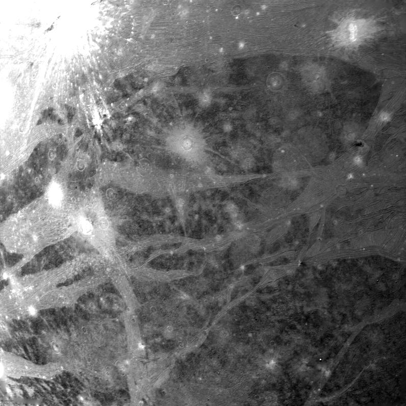
On the afternoon of March 5, 1979, Voyager 1 took this picture of Ganymede, Jupiter's largest satellite, from a range of 246,000 km (158,400 mi). The center of the picture is at 19 south latitude and 356 longitude, and the height of the frame represents a distance of about 1000 km (600 mi) on the surface. The smallest features seen on this picture are about 2.5 km (1.5 mi) across. The surface displays numerous impact craters many of which have extensive bright ray systems. The craters lacking ray systems are probably older than those showing rays. Bright bands traverse the surface in various directions and these bright bands contain an intricate system of alternating linear bright and dark lines which may represent deformation of the crusted ice layer. These lineations are particularly evident near the top of the picture. A bright band trending in a north-south direction in the lower left-hand portion of the picture is offset along a bright line. This offset is probably due to faulting. Two light circular areas in the right upper center of the picture may be the scars of ancient impact craters which have had their topographic expansion erased by flowage of the crystal icy material.
Background Info:
JPL manages and controls the Voyager project for NASA's Office of Space Science.
Cataloging Keywords:
| Name | Value | Additional Values |
|---|---|---|
| Target | Ganymede | |
| System | Jupiter | |
| Target Type | Satellite | |
| Mission | Voyager | |
| Instrument Host | Cassini Orbiter | Voyager 1 |
| Host Type | Orbiter | Flyby Spacecraft |
| Instrument | Imaging Science Subsystem (ISS) | |
| Detector | ||
| Extra Keywords | Crater, Grayscale, Impact | |
| Acquisition Date | ||
| Release Date | 2000-05-25 | |
| Date in Caption | 1979-03-05 | |
| Image Credit | NASA/JPL | |
| Source | photojournal.jpl.nasa.gov/catalog/PIA02279 | |
| Identifier | PIA02279 | |