skip to navigation

|
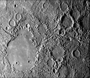
Hilly and Lineated Terrain
- Click the image above for a larger view
- Full-Res JPEG (356 x 311) (35.1 kB)
- Full-Res TIFF (356 x 311) (132.5 kB)
Caption:
Hilly and lineated terrain and a patch of smooth plains in a large degraded crater (lower left portion of the image). Linear scalloped valleys extend mostly NW from the center (e.g., Arecibo Vallis); some trend NNE. Small craters are rare in the terrain; most landforms are positive. Area centered at 28 degrees S, 22 degrees W measures 450 km across. Mariner 10 frame 27370 taken during the spacecraft's first encounter with Mercury.
Background Info:
The Mariner 10 mission, managed by the Jet Propulsion Laboratory for NASA's Office of Space Science, explored Venus in February 1974 on the way to three encounters with Mercury-in March and September 1974 and in March 1975. The spacecraft took more than 7,000 photos of Mercury, Venus, the Earth and the Moon.
Cataloging Keywords:
| Name | Value | Additional Values |
|---|---|---|
| Target | Mercury | |
| System | ||
| Target Type | Planet | |
| Mission | Mariner | National Astronomy and Ionosphere Center (NAIC) |
| Instrument Host | Arecibo Observatory | Mariner 10 |
| Host Type | Ground-Based Observatory | Flyby Spacecraft |
| Instrument | Arecibo Radar | |
| Detector | ||
| Extra Keywords | Crater, Grayscale, Moon | |
| Acquisition Date | ||
| Release Date | 2000-01-18 | |
| Date in Caption | ||
| Image Credit | NASA/JPL/Northwestern University | |
| Source | photojournal.jpl.nasa.gov/catalog/PIA02445 | |
| Identifier | PIA02445 | |
