
|
Topographic Profiles from the NEAR Laser Rangefinder
- Click the image above for a larger view
- Full-Res JPEG (800 x 600) (56.6 kB)
- Full-Res TIFF (800 x 600) (287.9 kB)
Caption:
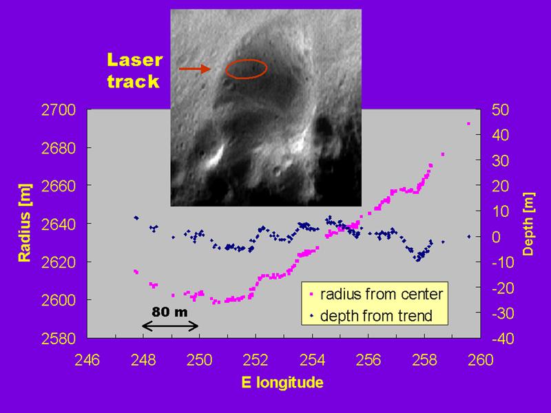
The NEAR Laser Rangefinder obtained this "staircase" altimetric profile from within the wall of the 6 kilometer (3.7 mile) diameter crater shown in the image inset. The profile represents ten minutes of data obtained from a range of 217 km (135 miles) on March 2, 2000. The purple points are a plot of radius from the center of Eros (left axis), and the blue points show the same measurements but with the overall trend removed (right axis). The laser track runs from left to right approximately in a line along the major axis of the red ellipse drawn on the image. The laser profile reveals a series of shallow depressions, about 50 to 80 meters (162 to 260 feet) wide and 5 to 10 meters (16 to 32 feet) deep, that may be a chain of pits or craters. Alternatively, the "staircase" profile may be the signature of a series of small ridges. The spatial structure and origin of the features producing the staircase will be revealed as the laser rangefinder accumulates elevation measurements during its one-year mapping mission of Eros.
Background Info:
Built and managed by The Johns Hopkins University Applied Physics Laboratory, Laurel, Maryland, NEAR was the first spacecraft launched in NASA's Discovery Program of low-cost, small-scale planetary missions. See the NEAR web page at http://near.jhuapl.edu/ for more details.
Cataloging Keywords:
| Name | Value | Additional Values |
|---|---|---|
| Target | 433 Eros | |
| System | Near Earth Objects | |
| Target Type | Asteroid | |
| Mission | NEAR Shoemaker | |
| Instrument Host | NEAR Shoemaker | |
| Host Type | Orbiter | |
| Instrument | NEAR Laser Rangefinder (NLR) | |
| Detector | ||
| Extra Keywords | Color, Crater | |
| Acquisition Date | ||
| Release Date | 2000-06-10 | |
| Date in Caption | 2000-03-02 | |
| Image Credit | NASA/JPL/JHUAPL | |
| Source | photojournal.jpl.nasa.gov/catalog/PIA02486 | |
| Identifier | PIA02486 | |