|
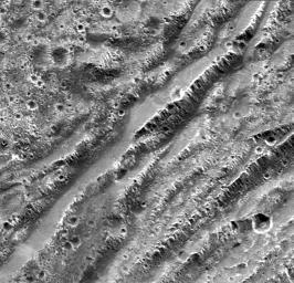
Stair-step Scarps in Dark Terrain on Ganymede
- Click the image above for a larger view
- Full-Res JPEG (795 x 767) (143.8 kB)
- Full-Res TIFF (795 x 767) (615.6 kB)
Caption:
NASA's Galileo spacecraft took this image of dark terrain within Nicholson Regio, near the border with Harpagia Sulcus on Jupiter's moon Ganymede. The ancient, heavily cratered dark terrain is faulted by a series of scarps.
The faulted blocks form a series of "stair-steps" like a tilted stack of books. On Earth, similar types of features form when tectonic faulting breaks the crust and the intervening blocks are pulled apart and rotate. This image supports the notion that the boundary between bright and dark terrain is created by that type of extensional faulting.
North is to the right of the picture and the Sun illuminates the surface from the west (top). The image is centered at -14 degrees latitude and 320 degrees longitude, and covers an area approximately 16 by 15 kilometers (10 by 9 miles). The resolution is 20 meters (66 feet) per picture element. The image was taken on May 20, 2000, at a range of 2,090 kilometers (1,299 miles).
This image was produced by Brown University, Providence, R.I., http://www.planetary.brown.edu/ .
Background Info:
This image and other images and data received from Galileo are posted on the Galileo mission home page at http://www.jpl.nasa.gov/galileo . Background information and educational context for the images can be found at http://www.jpl.nasa.gov/galileo/sepo
The Jet Propulsion Laboratory, a division of the California Institute of Technology in Pasadena, manages the Galileo mission for NASA's Office of Space Science, Washington, D.C.
Cataloging Keywords:
| Name | Value | Additional Values |
|---|---|---|
| Target | Ganymede | |
| System | Jupiter | |
| Target Type | Satellite | |
| Mission | Galileo | |
| Instrument Host | Galileo Orbiter | |
| Host Type | Orbiter | |
| Instrument | Solid-State Imaging (SSI) | |
| Detector | ||
| Extra Keywords | Crater, Grayscale, Rotation | |
| Acquisition Date | ||
| Release Date | 2000-12-16 | |
| Date in Caption | 2000-05-20 | |
| Image Credit | NASA/JPL/Brown University | |
| Source | photojournal.jpl.nasa.gov/catalog/PIA02582 | |
| Identifier | PIA02582 | |
