|
Mars Crustal Magnetic Field Remnants
- Click the image above for a larger view
- Full-Res JPEG (4000 x 2769) (959.2 kB)
- Full-Res TIFF (4000 x 2769) (11.8 MB)
Caption:
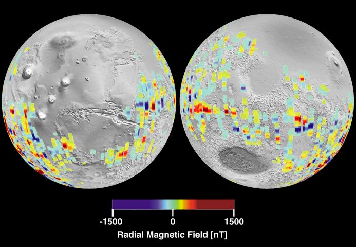
The radial magnetic field measured is color coded on a global perspective view that shows measurements derived from spacecraft tracks below 200 km overlain on a monochrome shaded relief map of the topography.
This image shows especially strong Martian magnetic fields in the southern highlands near the Terra Cimmeria and Terra Sirenum regions, centered around 180 degrees longitude from the equator to the pole. It is where magnetic stripes possibly resulting from crustal movement are most prominent. The bands are oriented approximately east - west and are about 100 miles wide and 600 miles long, although the longest band stretches more than 1200 miles.
The false blue and red colors represent invisible magnetic fields in the Martian crust that point in opposite directions. The magnetic fields appear to be organized in bands, with adjacent bands pointing in opposite directions, giving these stripes a striking similarity to patterns seen in the Earth's crust at the mid-oceanic ridges.
These data were compiled by the MGS Magnetometer Team led by Mario Acuna at the Goddard Space Flight Center in Greenbelt, MD.
Cataloging Keywords:
| Name | Value | Additional Values |
|---|---|---|
| Target | Mars | |
| System | ||
| Target Type | Planet | |
| Mission | Mars Global Surveyor (MGS) | |
| Instrument Host | Mars Global Surveyor | |
| Host Type | Orbiter | |
| Instrument | Magnetometer | |
| Detector | ||
| Extra Keywords | Color, Magnetosphere, Map | |
| Acquisition Date | ||
| Release Date | 2001-01-17 | |
| Date in Caption | ||
| Image Credit | NASA/JPL | |
| Source | photojournal.jpl.nasa.gov/catalog/PIA02819 | |
| Identifier | PIA02819 | |