
|
Defrosting South #2
- Click the image above for a larger view
- Full-Res JPEG (672 x 1580) (351.9 kB)
- Full-Res TIFF (672 x 1580) (1.1 MB)
Caption:
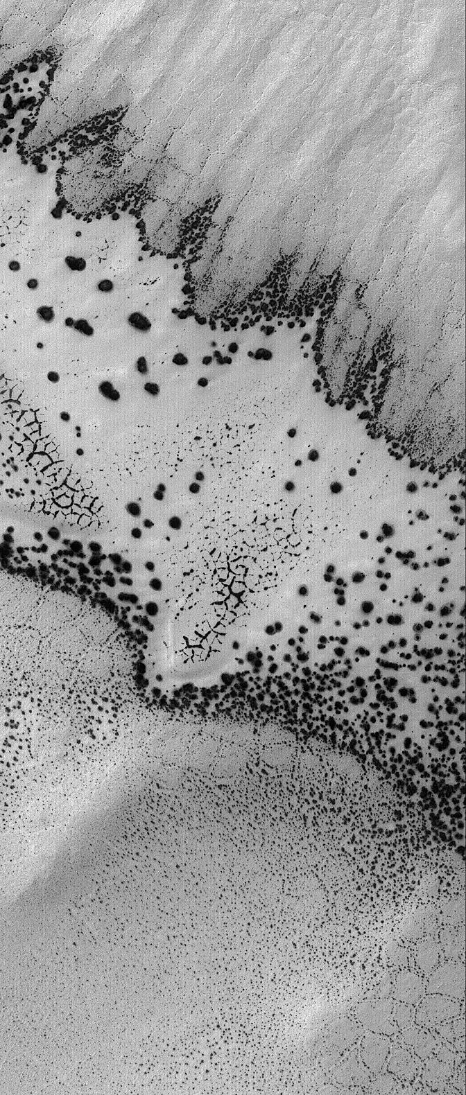
1 October 2005
This Mars Global Surveyor (MGS) Mars Orbiter Camera (MOC) image shows a second view of varied springtime defrosting patterns formed in a dune field and surrounding polygon-patterned ground in the south polar region of Mars. The previous view was featured as a MOC Picture of the Day on 20 August 2005 (
PIA04162
). Both images show portions of the same terrain and occur within a few hundred meters of each other. The previous release explained that the feature sporting an outline of dark spots and an interior of smaller, closely-spaced dark spots and dark-outlined polygons is a patch of windblown or wind-eroded sand that was covered by carbon dioxide frost during the previous autumn and winter. The fainter, larger polygon pattern on either side of the patch of defrosting sand is formed in the substrate upon which the sand patch is sitting. Polygonal forms such as these might indicate the presence of ice below the surface.
Location near
: 79.9°S, 125.9°W
Image width
: width: ~3 km (~1.9 mi)
Illumination from
: upper left
Season
: Southern Spring
Cataloging Keywords:
| Name | Value | Additional Values |
|---|---|---|
| Target | Mars | |
| System | ||
| Target Type | Planet | |
| Mission | Mars Global Surveyor (MGS) | |
| Instrument Host | Mars Global Surveyor | |
| Host Type | Orbiter | |
| Instrument | Mars Orbiter Camera (MOC) | |
| Detector | ||
| Extra Keywords | Atmosphere, Dune, Grayscale, Storm | |
| Acquisition Date | ||
| Release Date | 2005-10-01 | |
| Date in Caption | 2005-08-20 | 2005-10-01 |
| Image Credit | NASA/JPL/Malin Space Science Systems | |
| Source | photojournal.jpl.nasa.gov/catalog/PIA03007 | |
| Identifier | PIA03007 | |