|
Landmarks at NEAR Shoemaker’s Touchdown Site
- Click the image above for a larger view
- Full-Res JPEG (1482 x 1288) (217.4 kB)
- Full-Res TIFF (1482 x 1288) (1.8 MB)
Caption:
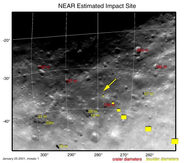
This map projection of NEAR Shoemaker images shows locations and sizes of landmarks surrounding the spacecraft's planned landing site. Diameters of craters are shown in red, and diameters of boulders are shown in yellow. Diameters are given in units of meters (1 meter is about 3.3 feet). Coordinates along the left side of the map are degrees south latitude and coordinates along the bottom are degrees west longitude.
The six yellow "footprint" boxes represent approximate image size at 500,1,000, 1,500, 2,000, 2,500 and 3,000 meters above the surface during descent. The spacecraft will take pictures continuously between each spot. The arrow marks the estimated touchdown site.
Mosaic made from images taken January 25, 2001, from an altitude of about 25 kilometers (16 miles).
Background Info:
Built and managed by The Johns Hopkins University Applied Physics Laboratory, Laurel, Maryland, NEAR was the first spacecraft launched in NASA's Discovery Program of low-cost, small-scale planetary missions. See the NEAR web page at http://near.jhuapl.edu/ for more details.
Cataloging Keywords:
| Name | Value | Additional Values |
|---|---|---|
| Target | 433 Eros | |
| System | Near Earth Objects | |
| Target Type | Asteroid | |
| Mission | NEAR Shoemaker | |
| Instrument Host | NEAR Shoemaker | |
| Host Type | Orbiter | |
| Instrument | Multi-Spectral Imager (MSI) | |
| Detector | ||
| Extra Keywords | Color, Crater, Map | |
| Acquisition Date | ||
| Release Date | 2001-02-17 | |
| Date in Caption | 2001-01-25 | |
| Image Credit | NASA/JPL/JHUAPL | |
| Source | photojournal.jpl.nasa.gov/catalog/PIA03144 | |
| Identifier | PIA03144 | |