
|
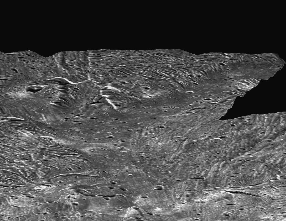
Ganymede Topography
- Click the image above for a larger view
- Full-Res JPEG (1089 x 842) (182.9 kB)
- Full-Res TIFF (1089 x 842) (586.4 kB)
Caption:
This perspective view, simulating a low altitude flight over the surface of Ganymede, was made possible by topographic analysis of stereo images of the Sippar Sulcus region. Such a view was made possible when Galileo passed Ganymede in May 1997, providing a virtual second "eye" to Voyager's first view in 1979.
Because this view covers a large area, it reveals that younger, smoother terrains are low-lying relative to older, heavily faulted terrains. The consistently low elevations of these smooth deposits has been cited as evidence for flooding of parts of Ganymede by low-viscosity lavas, most likely liquid water or water-ice slush.
This view is centered at 35 degrees south, 180 degrees west. The smallest features visible are roughly 350 to 400 meters (1,150 to 1,300 feet) across.
This image was prepared by the Lunar and Planetary Institute, Houston, and included in a report by Dr. Paul Schenk et al . in the March 1, 2001, edition of the journal Nature .
Background Info:
The Jet Propulsion Laboratory, a division of the California Institute of Technology in Pasadena, manages the Galileo and Voyager missions for NASA's Office of Space Science, Washington, D.C.
Images and data received from Galileo are posted on the Galileo mission home page at http://www2.jpl.nasa.gov/galileo/ . Background information and educational context for the images can be found at http://www2.jpl.nasa.gov/galileo/sepo/ .
Cataloging Keywords:
| Name | Value | Additional Values |
|---|---|---|
| Target | Ganymede | |
| System | Jupiter | |
| Target Type | Satellite | |
| Mission | Galileo | Voyager |
| Instrument Host | Galileo Orbiter | |
| Host Type | Orbiter | Flyby Spacecraft |
| Instrument | Solid-State Imaging (SSI) | |
| Detector | ||
| Extra Keywords | Grayscale, Water | |
| Acquisition Date | ||
| Release Date | 2001-03-13 | |
| Date in Caption | 2001-03-01 | |
| Image Credit | NASA/JPL/LPI | |
| Source | photojournal.jpl.nasa.gov/catalog/PIA03218 | |
| Identifier | PIA03218 | |